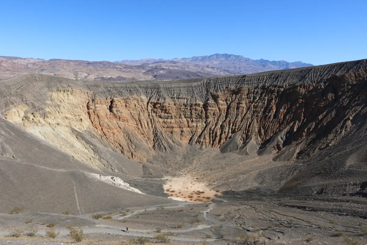
Ubehebe Crater's rim trail serves up Death Valley's most accessible volcanic spectacle—a 2,100-year-old crater punched half a mile wide into the northern reaches of the park. The 1.5-mile loop delivers big payoff for modest effort, but comes with exposure that'll test anyone squeamish about heights.
Trail Details
- 🏃Activities
- Hiking
- 📊Difficulty
- Moderate
- 🔁Trail Type
- loop
- 📏Distance
- 1.5 miles
- ⬆️Elevation Gain
- 500 ft
- 📍Location
- CA
- 🐕Dogs Allowed
- No
- 💵Fee
- Free
Overview
The crater drops 500 to 777 feet depending on where you measure, and the rim trail traces its irregular perimeter through a landscape that feels more lunar than terrestrial. This isn't a gentle nature walk. The trail follows exposed ridges where wind regularly howls across the volcanic debris, and the drop-offs are real enough to demand attention. Most hikers stick to the counter-clockwise direction, which starts with the steepest climb and gets the elevation gain out of the way early.
The payoff is immediate and sustained. From any point along the rim, you're looking down into a perfectly preserved blast crater, its walls striped with volcanic layers and debris flows. The silence is profound when the wind drops, broken only by the occasional rumble of rockfall from the crater walls.
What to Expect
The trail begins at the parking area directly overlooking the main crater. Within the first half-mile, you'll reach Little Hebe Crater—a smaller, shallower sibling that makes a reasonable turnaround point for those looking to cut the distance short. From here, the path continues around Ubehebe's irregular rim, offering changing perspectives on both the main crater and the surrounding Grapevine Mountains.
The terrain is loose volcanic scoria and hardpan, with occasional rocky sections that require attention. Footing is generally stable, but the constant awareness of the exposure keeps you focused. The rim itself is narrow in places, and while there are no technical sections, this isn't the place to let your mind wander.
Temperatures along the rim run cooler than the valley floor, sometimes dramatically so when the wind picks up. The elevation here—around 2,400 feet—provides some relief from Death Valley's notorious heat, but also creates its own weather patterns. Expect wind, and dress accordingly.
Tips & Logistics
The drive to Ubehebe Crater is part of the experience—33 miles north from the Furnace Creek area, with the final approach on a one-way loop road. The paved parking area handles large RVs without trouble, which speaks to this trail's popularity among the tour bus crowd during peak season.
No facilities exist at the trailhead beyond parking. The nearest restrooms are 5 miles east at the unstaffed Grapevine Ranger Station. Bring water; there are no sources anywhere along the route, and the combination of elevation, wind, and desert air will dehydrate you faster than you think.
Early morning offers the best conditions—calmer winds, better light for photography, and fewer crowds. During summer months, start before 10 AM or skip it entirely. The trail offers no shade whatsoever, and the volcanic rock amplifies heat.
The standard park entrance fee applies, and like all Death Valley trails, pets aren't allowed even if carried. Cell service is nonexistent this far north in the park.
For those wanting to extend the experience, a steep 0.25-mile descent leads to the crater floor, adding another 500 feet of elevation change to your day. The climb back out is legitimate work, but puts you directly in touch with the raw power that carved this hole in the earth 2,100 years ago.