Sentinel Dome delivers Yosemite's biggest visual payoff for the least effort. This granite knob sits 4,130 feet above the Valley floor, offering 360-degree views that include Half Dome, El Capitan, and the high Sierra — all accessible via a 2.2-mile round trip that most people can knock out in 90 minutes.
Trail Details
- 🏃Activities
- Hiking
- 📊Difficulty
- Moderate
- 🔁Trail Type
- out and back
- 📏Distance
- 2 miles
- ⬆️Elevation Gain
- 400 ft
- 📍Location
- CA
- 🐕Dogs Allowed
- No
- 💵Fee
- Free
Overview
The trail to Sentinel Dome follows the Sierra's granite-slab hiking playbook: wide, mostly gentle terrain across open rock marked by occasional cairns. You're hiking at 7,700 feet through country that feels more like the high Sierra than the Valley floor, with whitebark pines scattered across the granite and views opening up almost immediately.
The dome itself is a classic example of Yosemite's exfoliation geology — layers of granite peeling away like an onion to create the rounded summit. Unlike Half Dome's cables or the technical scrambles elsewhere in the park, Sentinel Dome's northeast slope provides a walkable route to the top, though the final stretch will get your heart rate up.
This is famously the spot where Ansel Adams photographed a lone Jeffrey pine in 1940, one of his most recognizable images. That tree died in 1977 and finally toppled in 2003, but the view that made it famous remains unchanged.
What to Expect
The trail starts from the Taft Point trailhead on Glacier Point Road, sharing parking with that equally popular destination. Early sections cross granite slabs with minimal shade — bring sun protection and start early in summer heat. The route is well-cairned where it crosses open rock, but the path is obvious enough that navigation isn't a concern.
Most of the elevation gain happens gradually over the first mile. The trail deposits you at the base of Sentinel Dome's rounded summit, where the real work begins. The final 0.1 miles involves scrambling up the granite slope itself — steep but short, with good friction even when the rock is dry. If there's snow or ice on the dome, micro-spikes become essential.
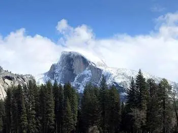
The summit plateau is large enough for groups to spread out, with drop-offs on multiple sides that plunge up to 2,000 feet. The views span the entire central Sierra: Half Dome and Clouds Rest to the east, El Capitan and Cathedral Rocks framing the Valley below, Yosemite Falls across the canyon, and the high peaks of the Cathedral Range on the horizon.
Tips & Logistics
Glacier Point Road controls access here, typically opening in late May and closing with the first significant snow in October or November. Even after the road opens, expect possible snow on the dome itself for the first few weeks — call 209/372-0200 for current conditions.
Parking at the Taft Point trailhead fills quickly during peak season. There's an overflow lot, but spots remain competitive. Bathrooms and bear boxes are available at the trailhead, though there's no water source on the trail itself.
The open granite means afternoon thunderstorms are genuinely dangerous — lightning strikes Sentinel Dome regularly. Start early to be off the summit by noon during summer months. Conversely, sunset from the dome is spectacular if you're willing to hike out by headlamp.
The $35 vehicle entrance fee covers three days in the park. Vehicles longer than 30 feet and those pulling trailers aren't permitted past the Sentinel Dome parking area, and overnight parking is prohibited beginning October 15.