Road's End sits at the terminus of Highway 180 in Kings Canyon, where the pavement stops and the High Sierra begins. This isn't a single trail but a trailhead complex that feeds into some of the most remote backcountry in California — from easy meadow loops to multiday expeditions toward the John Muir and Pacific Crest trails. It's your launch point into a canyon system that rivals Yosemite for drama but sees a fraction of the visitors.
Trail Details
- 🏃Activities
- Hiking
- 🪨Surface
- hard-packed dirt
- 🌤️Best Seasons
- april, may, june, july, august, september, october, november
- 📍Location
- CA
- 🐕Dogs Allowed
- No
- 💵Fee
- Free
Overview
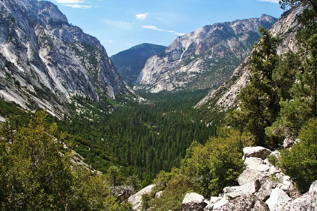
Road's End occupies the spot where Kings Canyon's granite walls squeeze the valley down to its narrowest point. The Kings River runs cold and clear here, fed by snowmelt from peaks you can't yet see. Most visitors use this as a day hiking base, sampling the canyon floor trails before the road closes them off for winter. But the real draw is what lies beyond: trail networks that climb out of the valley toward lake basins, high passes, and weeks' worth of Sierra wilderness.
The contrast is immediate. Walk five minutes on the Zumwalt Meadows loop and you're in classic Sierra meadow habitat with granite domes reflected in still water. Take the trail toward Mist Falls and you're gaining elevation through mixed conifer forest toward one of the park's largest waterfalls. Head up Bubbs Creek or toward Paradise Valley and you're committing to serious elevation gain that opens up views back down the canyon you just climbed out of.
What to Expect
The easy options stay close to the valley floor. Zumwalt Meadows gives you the granite-and-meadow experience without the commitment — a short loop that crosses the Kings River on a bridge and traces the base of the canyon walls. Roaring River Falls requires even less effort: a brief paved walk to a waterfall that runs strong through early summer.
Mist Falls represents the middle ground. The eight-mile round-trip covers mostly gentle terrain until the final push, where you gain 600 feet in the last stretch to reach the falls. This trail gets busy by Kings Canyon standards, but that still means solitude compared to comparable hikes in Yosemite.
The longer options — trails toward Bubbs Creek, Paradise Valley, and Copper Creek — climb out of the valley quickly and commit you to elevation gain. These routes offer the payoff views back down into Kings Canyon, but they're also your entry points into multiday territory. The backcountry beyond Road's End connects to trail networks that can keep you occupied for weeks.
Tips & Logistics
Highway 180 closes in mid-November and reopens the fourth Friday in April, weather permitting. That seasonal closure affects everything here — plan accordingly. Summer brings heat to the canyon floor, so carry more water than you think you need and start early for longer hikes.
This is active bear country. Follow food storage protocols even on day hikes. The bears here are habituated to hikers but not yet problematic like their Yosemite cousins — keep it that way.
Day hiking requires no permits, but overnight trips need wilderness permits available up to six months in advance through Recreation.gov. The permits go fast for popular entry points, especially summer weekends. Primitive camping is available near the trailheads for backpackers with permits.
Road's End marks the beginning of some of the Sierra's most committing backcountry. Once you leave the valley floor behind, there are no bailout roads or easy exits. You walk out the way you walked in, or you cross a high pass to the eastern Sierra. That remoteness is exactly what draws people here, but it demands preparation and self-sufficiency that casual day hiking doesn't require.