Sequoia & Kings Canyon National Parks
CA
Two parks managed as one, straddling the Great Western Divide in California's southern Sierra. Sequoia and Kings Canyon protect over 800,000 acres of granite peaks, glacier-carved canyons, and the largest trees on Earth — but the real draw for backcountry travelers is the scale. This is the heart of the largest contiguous wilderness in California, where multi-day routes cross passes above 13,000 feet and entire drainages see fewer visitors in a season than Yosemite gets in a weekend. The road to Mineral King alone filters out anyone who isn't serious about being here.
Details
- 🏞️Type
- National Park
- 🏛️Managed by
- National Park Service
- 📍State
- CA
- 🗺️Address
- 47050 Generals Highway, Three Rivers, CA, 93271
- 📞Phone
- 5595653341
- 🕐Hours
- The parks are open 24 hours a day, 365 days a year. Some park roads and roads that access more remote parts of the parks close in the winter due to snow accumulation. Rarely, extreme weather conditions may cause roads into the parks to be closed.
- 💵Entrance Fee
- $35 / vehicle
- 🐾Pets Allowed
- No
- ♿Accessibility
- limited
- 🥾Activities
- auto and atv, scenic driving, astronomy, stargazing, camping, backcountry camping, car or front country camping, horse camping (see also horse/stock use), group camping, rv camping, caving, climbing, rock climbing, fishing, freshwater fishing, fly fishing, food, dining, picnicking, guided tours, hands-on, citizen science, hiking, backcountry hiking, front-country hiking, horse trekking, horseback riding, junior ranger program, skiing, cross-country skiing, snow play, snowshoeing, wildlife watching, birdwatching, park film, museum exhibits, shopping, bookstore and park store, gift shop and souvenirs
- 📡GPS
- 36.71277, -118.58743
The Place
Sequoia and Kings Canyon are technically two national parks, administered together since the 1940s, but the distinction barely matters once you're past the sequoia groves. The western edge of the parks sits in oak-and-chaparral foothills below 2,000 feet. The eastern boundary traces the crest of the Sierra Nevada above 13,000 feet. Between those extremes is everything: old-growth sequoia groves, roaring river canyons, vast subalpine lake basins, and the highest peak in the Lower 48 — Mount Whitney, at 14,505 feet, just barely inside Sequoia's southeastern boundary.
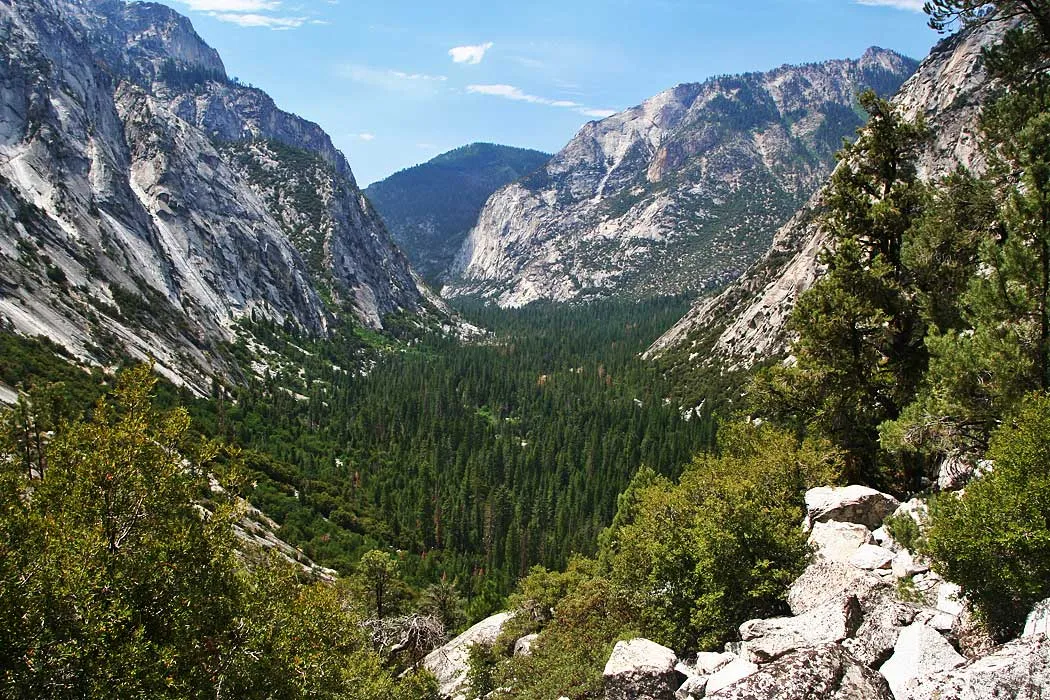
Kings Canyon — the canyon itself — is a glacier-carved trench more than a mile deep. It has the same geology and dramatic U-shape as Yosemite Valley, but without the hotels, shuttle buses, or crowds at the bottom. Cedar Grove sits at the end of a seasonal road with a small lodge, a general store, and a trailhead into some of the most committing backcountry in California. Once you leave Roads End, there are no bail-out roads. You walk out the way you walked in, or you cross a 12,000-foot pass to the east side of the Sierra.
What separates SEKI's backcountry from Yosemite or the John Muir Wilderness is the remoteness and the commitment level. The approaches are longer, the drainages are deeper, and there's less ranger presence in the interior. Kings Canyon received roughly 700,000 total visitors last year — compared to Yosemite's four million-plus — and most of those visitors never leave the sequoia groves. The ratio in the backcountry is even more skewed. Cloud Canyon, the Roaring River, the Hockett Plateau, Tehipite Valley — these places exist in a different register of solitude than anything in the more popular Sierra parks.
Getting There & Getting In
Two highways access the parks from California's Central Valley. Highway 180 from Fresno enters Kings Canyon and continues 30 miles east to Cedar Grove and Roads End — the main backcountry launching point for the north side of the parks. Highway 198 from Visalia enters Sequoia through Three Rivers and climbs to the Giant Forest area. The Generals Highway connects the two, but vehicles over 22 feet should use Highway 180 only.
Highway 180 to Cedar Grove is seasonal and typically opens in late April. Mineral King Road — 25 miles of narrow, winding, partially unpaved switchbacks with 698 curves — usually opens in late May. Both roads close when winter snow accumulates, though exact dates shift year to year. The Generals Highway between the parks can also close during winter storms. Check current road status before driving — chain requirements are common in winter and spring.
For eastern Sierra access, Onion Valley (Kearsarge Pass trailhead, 9,200 feet) on the Inyo National Forest side provides a back door into the Rae Lakes area and the JMT/PCT corridor. It's a useful option for through-routes and for acclimatization — starting higher means less altitude shock.
Cell coverage is functionally nonexistent in the backcountry and spotty even at developed areas. Don't count on it at Cedar Grove or Mineral King. The nearest reliable coverage is in Three Rivers or Fresno.
When to Go
Summer (mid-July through mid-September) is prime time for high-route backpacking. Passes are generally snow-free, water is running, and weather is stable with afternoon thunderstorm risk. July and August weekends are the busiest, but mid-week starts thin the crowds considerably. September is a sweet spot — warm days, cool nights, lower water crossings, and permit quotas end in late September.
Early summer (late May through mid-July) brings snow on high passes and high water on river crossings. Glen Pass, Forester Pass, and the Mineral King passes may require ice axes and microspikes. Lower-elevation routes below 9,000 feet are in good shape, and the foothills are green before the summer burn. In heavy snow years, significant snowpack can linger on passes well into August.
Fall (late September through November) offers post-quota freedom — self-issue permits, no reservation needed. Roads are typically still open into October and November depending on early-season storms. Shorter days and lower water on side drainages, but the solitude is real.
Winter and spring bring snow to the sequoia groves and deep snowpack at higher elevations. The backcountry doesn't shut down — it changes character. Cross-country skiing and snowshoeing in the sequoia groves is outstanding. Higher-elevation travel becomes a winter mountaineering undertaking with avalanche terrain, route-finding on buried trails, and short days. Roads into the parks may require chains or be snow-closed, and seasonal roads like Highway 180 to Cedar Grove and Mineral King Road are generally not plowed. Plan access accordingly.
Permits & Regulations
All overnight backcountry trips require a wilderness permit. During quota season (late May through late September), permits are managed through Recreation.gov on a rolling basis, released six months in advance at 7:00 AM Pacific each day. There is no lottery — it's first-come, first-served when they drop, which means popular trailheads sell out within minutes of the window opening.
Each trailhead reserves a portion of its daily quota for walk-ups, available at permit stations in Cedar Grove, Grant Grove, Lodgepole, Ash Mountain, and Mineral King. Walk-up odds are reasonable on weekdays for most trailheads, but don't count on it for the High Sierra Trail from Crescent Meadow or the Woods Creek/Rae Lakes corridor during peak season.
Outside quota season, permits are free and self-issued at any permit station.
Bear canisters are mandatory from May 1 through October 31 in specific high-use zones: the Rae Lakes/Woods Creek/Bubbs Creek corridor, Dusy Basin and Palisade Basin, the Rock Creek drainage near Siberian Pass, and the Pear and Emerald Lakes area. Outside these zones, bear hangs are technically allowed, but carrying a canister everywhere is the practical move — bears are active throughout the parks and food-conditioned animals are a documented problem in the popular camping corridors.
Campfire restrictions vary by zone and fire danger level. Above 10,000 feet, fires are generally prohibited. Check current restrictions at the permit desk — they change throughout the season.
Lodging, Camping & Supplies
Inside the parks: Cedar Grove Lodge (21 rooms, seasonal, typically open when Highway 180 is) and Grant Grove Cabins (various types, some available year-round) are the only in-park lodging. Neither is fancy. The parks have over a dozen developed campgrounds between them — Lodgepole and Dorst Creek on the Sequoia side, Azalea and Sentinel on the Kings Canyon side are among the larger ones. Potwisha and Azalea stay open year-round; most others are seasonal. Check Recreation.gov for current availability and fees, as both change.
Small general stores operate at Lodgepole, Grant Grove, and Cedar Grove when those areas are open. They carry basic supplies, some camp fuel, and limited groceries — enough to fill a gap but not to provision a week-long trip. There are no gear shops in the parks.
Gateway towns: Three Rivers (Highway 198 side) is the closest town to Sequoia's entrance — a small community with a few restaurants, a market, and a gas station. It's not a major resupply point. Visalia, about an hour west, has full services including outdoor gear stores. On the Kings Canyon side, Fresno (about 90 minutes from Cedar Grove) is the nearest city with complete outfitting options. For eastern Sierra access via Kearsarge Pass, Independence and Lone Pine on Highway 395 have basic resupply — Lone Pine is the better option for gear and groceries.
For multi-day trips: Provision fully before you arrive. The in-park stores are supplements, not supply points. If you're doing a through-route like the High Sierra Trail, your resupply options are essentially zero between Crescent Meadow and Whitney Portal unless you cache.
Routes Worth Knowing
High Sierra Trail — 72 miles, Crescent Meadow to Whitney Portal. 6-8 days. The classic west-to-east trans-Sierra route, starting at 6,700 feet in the sequoia groves and finishing at 14,505 feet on Whitney's summit before dropping to Whitney Portal. Bear boxes and pit toilets at established camps along the way (Bearpaw Meadow, Hamilton Lake, Big Arroyo, Crabtree Meadow). The final push from Guitar Lake at 11,500 feet to the summit is where altitude hits hardest. Requires a car shuttle — Whitney Portal is a four-hour drive from Crescent Meadow.
Rae Lakes Loop — 41 miles, 3-5 days from Roads End. The most popular backpacking route in the parks, and for good reason. Glen Pass at 11,978 feet is the crux — steep, exposed, potentially snow-covered into July. The Rae Lakes basin is strikingly beautiful and you will not be alone there. Counter-clockwise (Paradise Valley up, Bubbs Creek down) is the standard direction. Bear canisters mandatory in the corridor.
Mineral King Loops — 37-45 miles depending on variation, 3-5 days. Multiple loop options linking Franklin Pass, Black Rock Pass, Sawtooth Pass, and the Big/Little Five Lakes basins. The trailhead sits at 7,800 feet, which gives you a head start on altitude. These routes are significantly less crowded than the Rae Lakes or HST — the road does its job. One logistical note: marmots at the Mineral King trailhead are notorious for chewing radiator hoses and car wiring. Wrapping your vehicle undercarriage in a tarp is standard procedure, not a joke.
Kearsarge-Forester-Shepherd-Junction Pass Loop — 46 miles, roughly 12,000 feet of cumulative gain. A serious high-altitude route combining four major passes, including Forester at 13,153 feet — the highest named pass on the JMT/PCT. This is not a casual loop.
Kings Canyon High Basin Route (Skurka) — 124 miles, two-thirds off-trail. Wraps the upper Kings River watershed with sustained class 2-3 scrambling and route-finding. Mentioned here because it exists and because it represents the upper end of what this backcountry offers. You'll know if it's for you.
Water, Weather & Hazards
Water is generally abundant through August along main drainages — the forks of the Kings River, the Kern, the Kaweah all run all season. Side streams and higher tributaries start drying up by late August, and by September many mapped streams are gone. Ridge traverses and pass approaches can have dry stretches of several miles. A study of backcountry water sites found coliform contamination at 40% of sampled locations, concentrated downstream of established camps and stock routes. Filter everything, and fill up before ascending away from drainages.
Afternoon thunderstorms are standard from July through September. Lightning exposure on the high passes is extreme — Glen, Forester, Franklin, and Black Rock are all fully exposed ridgeline terrain with no shelter. The standard rule applies: be off passes by noon. The Great Western Divide and Kaweah Peaks Ridge are particularly exposed.
River crossings on unbridged routes are a genuine hazard during peak snowmelt in June and early July. Woods Creek on the Rae Lakes Loop has multiple drowning incidents in its history. By late August, most crossings are straightforward.
The elevation range in these parks deserves respect. Starting from Roads End at 5,035 feet and reaching Glen Pass at 11,978 feet in two or three days is a nearly 7,000-foot gain. The HST's final Whitney push takes you from 11,500 to 14,505 feet. If you're coming from sea level, spend a night at a mid-elevation trailhead before starting any route that goes above 10,000 feet on day two.
One terrain note: the Kaweah Peaks Ridge and parts of the Monarch Divide are dark, loose metamorphic rock — fundamentally different from the solid granite that characterizes most of the Sierra. Off-trail travel in these zones is objectively more hazardous due to rockfall and unstable footing.
Finding Solitude
The crowds concentrate where you'd expect: Rae Lakes, the HST corridor through Bearpaw and Hamilton Lake, Pear and Emerald Lakes (short approach from Lodgepole), and the JMT/PCT through the Kern.
For solitude, look at Mineral King in general (the road does your filtering), the Hockett Plateau in southern Sequoia, the Roaring River and Cloud Canyon drainages, and anything in the Monarch Divide. Tehipite Valley is extremely remote with no road access and requires a multi-day approach — very few people go there.
Timing matters as much as destination. Late September and October — post-quota season, roads still open — offer a fundamentally different experience from peak summer. Mid-week starts in any season thin out even the popular routes. And in most years, early summer offers lower-elevation backcountry access before the high passes clear and the permit quotas fully kick in — you're limited in where you can go, but you'll have it to yourself.
Fees, permit costs, campground rates, road opening dates, and regulations change. For the latest information, check the official NPS website for Sequoia & Kings Canyon.