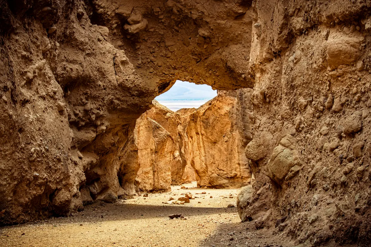
The Natural Bridge Trail leads to one of Death Valley's most accessible geological curiosities — a 35-foot arch carved from ancient alluvial deposits. The walk takes you straight up a desert wash to stand beneath the span, with minimal elevation gain but maximum payoff for the effort invested.
Trail Details
- 🏃Activities
- Hiking
- 📊Difficulty
- Easy
- 🔁Trail Type
- out and back
- 📏Distance
- 1 miles
- ⬆️Elevation Gain
- 86 ft
- 📍Location
- CA
- 🐕Dogs Allowed
- No
- 💵Fee
- Free
Overview
This is wash hiking at its most straightforward. No maintained trail exists, but the route is obvious: park at the end of Natural Bridge Road and walk directly up the canyon floor. The bridge appears after about a third of a mile, rising 35 feet above the wash and spanning the canyon with the same thickness. What makes it interesting beyond the novelty is the material — not the sandstone you'd expect, but a jagged conglomerate of rock, gravel, and sediment that washed down from ancient mountains and cemented together over time.
The setting feels surprisingly intimate for Death Valley. The wash walls close in around you, creating shade and shelter that the open valley floor never provides. It's one of the few spots in the park where you're hiking toward something specific and recognizable rather than into the general vastness.
What to Expect
The walking surface is loose gravel and rock debris — the kind of terrain that keeps you looking down at your feet. Sturdy footwear matters here. The wash bed shifts underfoot, and some sections can be slick despite the desert setting. The route gains less than 100 feet over a half mile, but the uneven surface makes it feel more involved than the numbers suggest.
The bridge itself marks a natural stopping point for most hikers, but the canyon continues beyond it. Those who push farther up the wash will encounter dry falls, marble chutes, and hanging side canyons before reaching a 20-foot dry waterfall where progress ends. The additional exploration adds another 0.4 miles to the round trip.
Tips & Logistics
Getting to the trailhead requires 1.5 miles of unpaved driving on Natural Bridge Road, which branches off Badwater Road 13.5 miles south of Highway 190. The dirt road is generally passable for standard vehicles, but check current conditions with rangers — Death Valley's access roads wash out regularly and stay closed for months.
The parking area accommodates buses and RVs, with a vault toilet on site. Standard park entry fees apply.
Summer timing is critical here. The park service explicitly advises against hiking after 10 AM during the hot months, and this trail has seen recent heat-related fatalities. When the Furnace Creek weather station hit 119°F in August 2024, someone died at this location that same afternoon. The wash provides some protection from direct sun, but not enough to matter when air temperatures reach triple digits.
Winter through early spring offers the most comfortable conditions, though even then, carry water and start early. The 45-minute round trip can stretch longer if you explore beyond the bridge, and Death Valley's dry air dehydrates faster than most people expect.
The no-pets policy applies throughout the park, so leave dogs behind. Cell service is nonexistent, as it is almost everywhere in Death Valley backcountry.