The Cabrillo Monument hike on San Miguel Island takes you to one of the most remote commemorative sites in the National Park System. This 2-mile round trip from Cuyler Harbor requires special permits and naval clearance to access—San Miguel is owned by the U.S. Navy and only open when park rangers are present. The payoff is standing at a 1937 monument above one of California's most isolated beaches, with the knowledge that you're among the few who make it here each year.
Trail Details
- 🏃Activities
- Hiking
- 📊Difficulty
- Hard
- 🔁Trail Type
- out and back
- 📏Distance
- 2 miles
- 📍Location
- CA
- 🐕Dogs Allowed
- No
- 💵Fee
- Free
- 📋Permit Required
- Yes
Overview
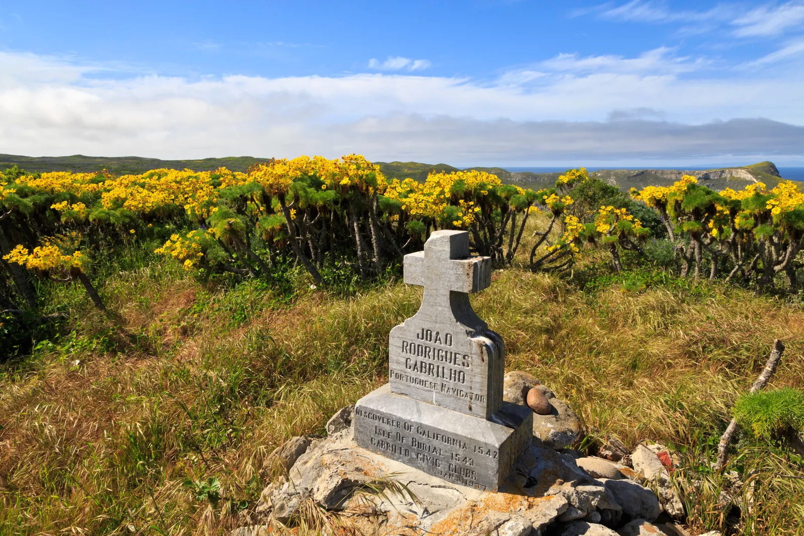
San Miguel sits 55 miles off the Ventura coast as the most westerly and wind-battered of the Channel Islands. The Cabrillo Monument hike follows the Nidever Canyon trail from Cuyler Harbor to a stone marker erected in 1937, honoring Juan Rodriguez Cabrillo's 1542 landing. This isn't a trail you stumble onto—access requires advance permits, liability waivers, and coordination with both the Navy and National Park Service.
The island's character is defined by isolation and restriction. San Miguel served as a bombing range for decades, and unexploded ordnance still surfaces on beaches and inland areas. The park service manages access carefully, limiting visitors to designated trails and requiring ranger accompaniment beyond certain points. What you get in return is an experience unlike anywhere else in the California park system.
What to Expect
The trail begins at the top of the dune above Gull Rock at Cuyler Harbor, climbing along the east wall of Nidever Canyon. The path is steep and slippery—the park service specifically warns about footing conditions. You'll gain 700 feet of elevation over the course of the hike, which may seem modest until you factor in the coastal winds and exposed terrain.
The route passes through the Lester Ranch site, remnants of the island's ranching era that ended in the 1960s. From Cuyler Harbor to the monument is roughly 2 miles round trip, though some sources put the ranch loop at 3 miles with similar elevation gain. The discrepancy likely depends on which ranch buildings you include in the tour.
At the monument itself, you'll find a stone marker overlooking the harbor where you landed. The site offers perspective on San Miguel's strategic position in the Santa Barbara Channel and the challenges Cabrillo's crew faced navigating these waters in the 16th century. On clear days, the other Channel Islands stretch east toward the mainland.
Tips & Logistics
San Miguel operates under strict access controls. You'll need advance permits that include liability waivers acknowledging the unexploded ordnance risk. The island is only open when park personnel are present, which limits visit windows significantly. Book transportation through Island Packers well in advance—San Miguel requires a multi-leg journey through Santa Rosa Island, making it a full-day commitment minimum.
Water is critical. There are no natural water sources on the trail, and the combination of elevation gain, coastal winds, and potential heat makes dehydration a real concern. The park service recommends using the buddy system and never hiking alone, which is sound advice given the island's isolation and limited ranger presence.
Stay on designated trails. This isn't just park policy—it's safety protocol. Unexploded ordnance from the bombing range era makes off-trail travel genuinely dangerous. If you encounter any suspicious metal objects, don't disturb them and report the location to rangers.
Pack out everything you bring. San Miguel's ecosystem is fragile, and the logistics of getting supplies to and from the island make waste management challenging. No pets, smoking, or fires are allowed anywhere on the island.
The ranger station near the monument can be reached on Marine Radio Channel 16, but don't count on cell coverage. Plan as if you're entirely self-sufficient until the return boat departure.