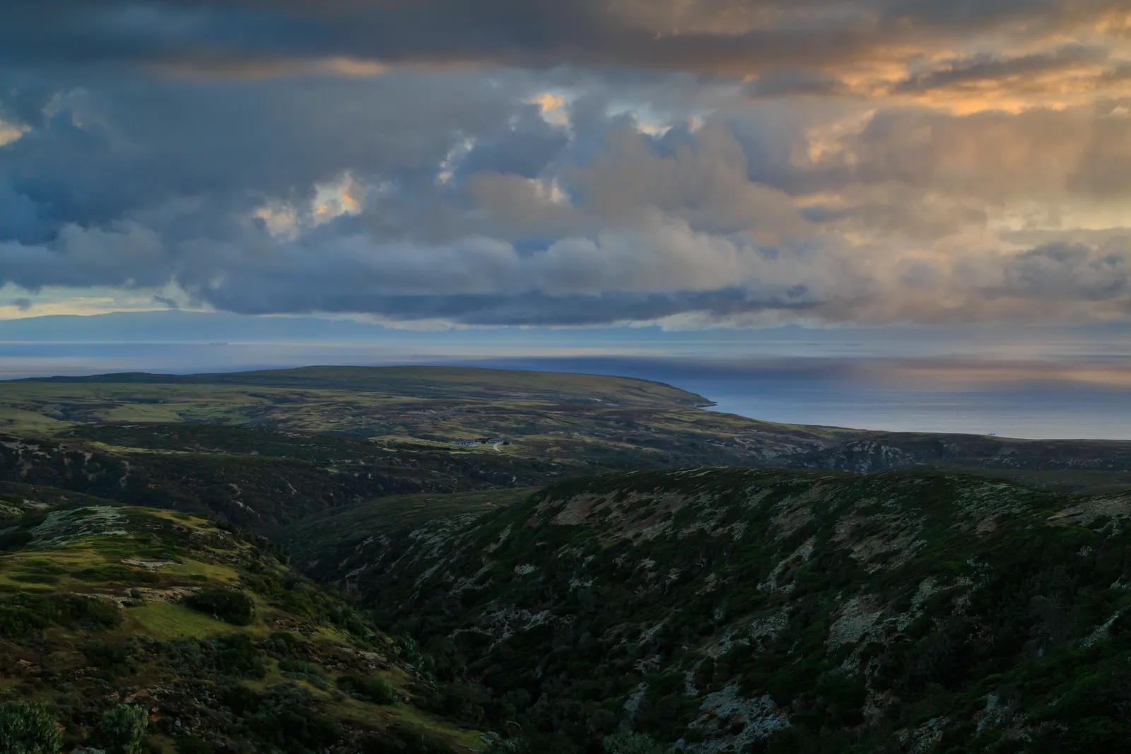
Black Mountain on Santa Rosa Island is the only true mountain trek in Channel Islands National Park — an 8-mile commitment that climbs over 1,200 feet to one of the highest points in the park system. The payoff is a 360-degree view that takes in three islands and the mainland coast, assuming the marine layer cooperates.
Trail Details
- 🏃Activities
- Hiking
- 📊Difficulty
- Hard
- 🔁Trail Type
- out and back
- 📏Distance
- 8 miles
- 📍Location
- CA
- 🐕Dogs Allowed
- No
- 💵Fee
- Free
Overview
This is hiking as endurance test. Santa Rosa Island doesn't coddle visitors with shade trees or meandering switchbacks. The route to Black Mountain follows service roads and rough trail across oak woodlands and exposed ridgeline, gaining elevation steadily from Water Canyon Campground. Weather permitting, you'll see Santa Cruz and San Miguel islands spread out below, plus the mainland coast stretching from Point Conception to the Santa Monica Mountains.
The island fox might be endemic to these parts, but shade is not. The trail offers little to no cover, and summer temperatures climb into the upper 80s. This isn't a casual morning stroll — it's a commitment that requires water planning and weather awareness.
What to Expect
The most direct approach starts from Water Canyon Campground and incorporates Cherry Canyon Trail and Telephone Road — a mix of established trail and service roads that keeps navigation straightforward. The terrain shifts from the protected canyon bottom through oak woodlands to exposed ridgeline walking as you gain elevation.
Those oak woodlands are worth noting. They're part of what makes Santa Rosa Island distinct from its neighbors — a remnant ecosystem that survived the island's ranching era. The trees provide some of the only reliable shade on the route, so use them strategically.
At the summit, the view takes in Becher Bay, Carrington Point, Cherry Canyon, and Water Canyon spread out below. On clear days, you can trace the coastlines of Santa Cruz and San Miguel islands, plus the mainland from Point Conception eastward. The catch: clear days are a gift, not a guarantee. Marine layer and wind are constants in the Santa Barbara Channel, and Black Mountain sits high enough to catch both.
Tips & Logistics
Water is everything on this hike. Santa Rosa is one of only two islands in the park with potable water at the campground, but that doesn't help you 4 miles out. Carry more than you think you need — the combination of elevation gain, exposure, and sea-level humidity will surprise mainland hikers.
Island Packers runs boat service to Santa Rosa Island from Ventura Harbor, but the crossing takes 3 hours and the ferry schedule controls your entire trip timeline. Bad weather can cancel boat service with little notice, so build flexibility into your mainland plans. The National Park Service doesn't manage transportation to the islands — that's all through Island Packers or private boat.
Sturdy boots matter more here than on most California trails. The combination of service roads, rocky terrain, and plant communities you won't encounter on the mainland creates different footing challenges. Gaiters aren't overkill — the island's endemic plants include some that grab at clothing and skin.
Never hike alone on any of the Channel Islands. The buddy system isn't just recommended safety protocol here — it's essential given the isolation and limited rescue options. Cell service is nonexistent, and help is hours away even under ideal conditions.
The loop option incorporating Cherry Canyon trail and the service roads adds variety to the route without significant additional mileage. It's worth considering if you've made the ferry commitment and want to see more of the island's interior terrain.