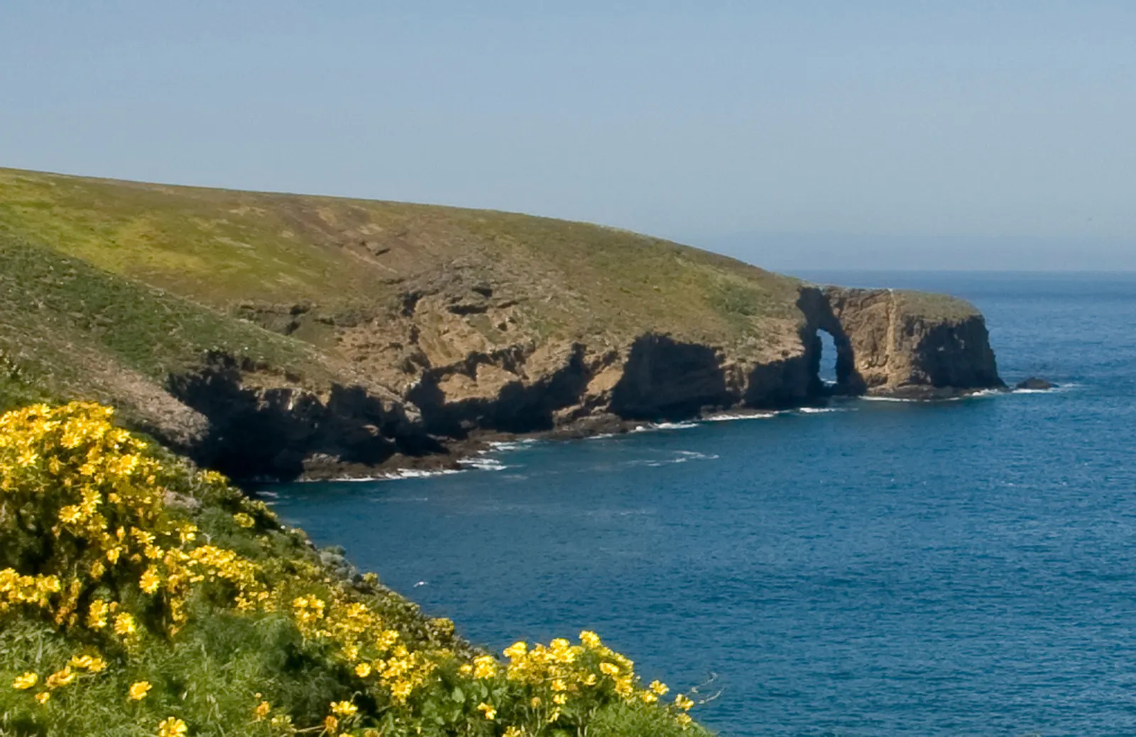
The half-mile walk to Arch Point serves as Santa Barbara Island's front porch — a gentle introduction to the Channel Islands' most remote outpost. This trail leads to the island's signature sea arch, a 130-foot portal carved by Pacific swells, offering your first real look at what isolation does to a landscape.
Trail Details
- 🏃Activities
- Hiking
- 🔁Trail Type
- out and back
- 📏Distance
- 1 miles
- 📍Location
- CA
- 🐕Dogs Allowed
- No
- 💵Fee
- Free
Overview
Santa Barbara Island floats alone, 38 miles south of the main Channel Islands chain. At one square mile, it's the park's smallest island and feels it. The Arch Point trail heads north from the visitor center, crossing the island's windswept plateau to reach the northeast shore where wave action and geological fault lines collaborated to punch a hole through the headland.
The trail itself won't challenge anyone — it's a straightforward walk across relatively flat terrain. What makes this hike significant is context: you're standing on a piece of land that broke away from the mainland millions of years ago and went its own evolutionary direction. The plant communities here exist nowhere else. Even the soil crunches differently underfoot.
What to Expect
The route follows the island's northern edge, with the Pacific stretching unbroken to the horizon. Wildflowers bloom in season, though the timing depends on rainfall patterns that can be wildly unpredictable from year to year. The arch itself commands the northeast tip — a natural bridge tall enough to frame passing boats and solid enough to withstand the storms that rake this coast each winter.
Coastal views dominate the experience. On clear days, you'll see the other Channel Islands strung along the northern horizon. The scale here is different from mainland hiking — distances that look short prove longer because there are no familiar reference points, no trees or buildings to judge size against. It's just sea, sky, and this small piece of land floating between them.
Tips & Logistics
Getting to Santa Barbara Island requires commitment. Island Packers runs limited service here — typically just a few trips per month, with longer gaps in winter when weather makes crossings unreliable. The boat ride from Ventura takes about three hours each way, and rough seas can cancel trips with little notice.
Once you arrive, you'll climb a steel ladder up the cliff face followed by 131 steps to reach the island proper. Pack accordingly — there's no water available on the island beyond what you carry, and no shelter beyond the small visitor center. The biosecurity protocols apply here as everywhere in the park: clean your boots and check your pack for hitchhiking seeds or insects before boarding the boat.
Weather defines the experience more than on the other islands. Santa Barbara Island catches the full force of Pacific storms and the notorious winds that funnel through the Santa Barbara Channel. Even on calm days, the breeze is constant. In spring, that wind carries the scent of wildflowers and seabird colonies. In winter, it carries salt spray and the promise that your return boat ride might turn into an adventure you didn't plan for.
The trail connects to the island's other routes if you want to make a longer day of it. From Arch Point, you can follow the bluffs south and eventually link up with the Signal Peak Loop Trail. But for most visitors, especially day-trippers, the arch makes a satisfying turnaround point — a chance to sit at the edge of the continent and contemplate just how far 38 miles of open ocean can feel.