Stanislaus National Forest
CA
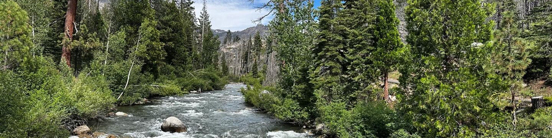
Stanislaus spreads across 898,000 acres of Central Sierra terrain — from oak-studded foothills to alpine cirques scraping 11,000 feet. This is where Highway 108 climbs to 9,623-foot Sonora Pass, one of the highest paved crossings in California, and where three wilderness areas hold some of the Sierra's most reliable solitude. Established in 1897, it's old enough to have weathered every boom-and-bust cycle of Sierra recreation, yet it still flies under the radar compared to its famous neighbors. Day hikers circle Pinecrest Lake, backpackers disappear into Emigrant Wilderness for weeks, and anyone seeking a less-crowded taste of High Sierra granite finds it here.
Details
- 🏞️Type
- National Forest
- 🏛️Managed by
- USDA Forest Service
- 📍State
- CA
- 🗺️Address
- 19777 Greenley Road, Sonora, CA, 95370
- 📞Phone
- (209) 532-3671
- 📡GPS
- 38.28130, -120.08780
The Place
The forest stretches across four counties in the Central Sierra, occupying the granite spine between Lake Tahoe and Yosemite. At its heart lie three wilderness areas: Emigrant (the forest manages all of it), plus chunks of Carson-Iceberg and Mokelumne. The elevation spread runs from 1,000 feet in the western foothills to over 11,000 feet along the Sierra Crest.
Water defines much of what you'll encounter: 78 lakes scattered across granite basins, 811 miles of streams and rivers carving through the landscape. The Tuolumne River system drains the southern portions, while the Stanislaus River gives the forest its name. Pinecrest Lake, at 300 acres, anchors the most developed recreation area.
The terrain transitions predictably as you climb. Western slopes hold oak woodland and chaparral, giving way to mixed conifer forests of pine, fir, and incense cedar around 3,000-6,000 feet. Higher elevations open into classic Sierra granite domes, cirque lakes, and wind-scoured peaks. Highway 108's climb to Sonora Pass offers one of the most dramatic elevation gains of any Sierra crossing — nearly 9,000 vertical feet from the Central Valley to the crest.
Getting There
Highway 108 provides the main artery, running east from Modesto and Sonora toward the Sierra Crest. From the San Francisco Bay Area, expect three hours to reach Sonora, then another hour to Pinecrest. From Sacramento, figure four hours to the main recreation areas. Highway 4 accesses the northern sections through the Calaveras District.
The Sonora Pass section of Highway 108 closes seasonally — typically from the first heavy snow (November) through May or June, depending on snowpack. Check Caltrans conditions before planning high-elevation trips. Even when open, the pass requires caution; it's steep, narrow, and not recommended for RVs over 24 feet.
Cell coverage exists sporadically. Expect service in developed areas like Pinecrest but plan for dead zones in wilderness areas and along high mountain roads.
When to Go
June through September offers the most reliable access to high-elevation areas. Snow can linger on north-facing slopes and high passes into July, making early season backpacking trips a gamble. August typically provides the best balance of snow-free trails and moderate fire danger.
Lower elevations remain accessible year-round, though winter brings mud and possible road closures on forest roads. Spring arrives early in the foothills — wildflower hikes around 3,000-4,000 feet can be excellent in April and May.
Fire season varies but typically runs July through October. Red flag days can trigger campfire bans and trail closures. Check current conditions before traveling during fire season.
Permits & Regulations
Wilderness permits are required for overnight stays in Carson-Iceberg, Mokelumne, and Emigrant Wilderness areas from April 1 through November 30. They're free but subject to group size limits: 15 people maximum in Emigrant and Carson-Iceberg, 12 in Mokelumne. Stock groups face additional restrictions.
Day hiking requires no permits, but group size limits still apply. The Summit Ranger Station on Highway 108 issues permits in person during office hours, with self-service kiosks available when closed. For Yosemite connections from Shingle Springs or Lake Eleanor trailheads, call the Groveland Ranger District one day in advance.
Campfire permits are required for any fire outside developed campgrounds and are available online. Groups larger than 20 people need special-use permits from the appropriate ranger district office.
Christmas tree permits run $10 per tree (two-tree maximum) through Recreation.gov during season.
Hiking & Routes
Over 1,000 miles of trails offer everything from lakeside strolls to multi-day wilderness routes. Pinecrest Lake's 3.9-mile loop remains the most popular day hike — easy enough for families but scenic enough to satisfy most visitors. Dogs are banned near the lake May 15-September 15.
For moderate day hiking, San Antonio Creek Falls near Arnold provides an easy walk to an 89-foot cascade. The Arnold Rim Trail system offers mid-elevation routes for hikers, mountain bikers, and equestrians.
Sonora Peak attracts peak-baggers seeking the forest's highest summit. The route starts from Sonora Pass and climbs above treeline for Sierra Crest views.
Backpackers gravitate toward Emigrant Wilderness, where the Crabtree Trail to Bear Lake covers 8.4 miles with 948 feet of elevation gain — rated the forest's best backpacking route by users. The wilderness offers everything from weekend loops to extended traverses connecting with Yosemite's high country.
For serious distance, the PCT crosses the forest for dozens of miles, with the Golden Canyon, Wolf Creek Pass, and Disaster Creek Loop stretching nearly 50 miles. The Emigrant Wilderness and Sachse Monument Loop packs 9,373 feet of elevation gain into a challenging circuit.
Camping
Twenty-one campgrounds scattered across the forest offer different experiences. Some operate on Recreation.gov reservations; others remain first-come, first-served. Most follow a 14-day limit.
Cherry Valley Campground near Tuolumne provides 41 single and 5 double sites but isn't suitable for RVs over 24 feet. It typically opens with fishing season in late April. Pinecrest Campground sits near the lake at a developed recreation area 30 miles east of Sonora.
Higher elevation options include Big Meadow Campground at 6,400 feet, located 21 miles east of Arnold. Rates vary by campground; Stanislaus River Campground charges $30 per night, with America the Beautiful passes providing 50% discounts.
Dispersed camping is permitted throughout the forest with standard Leave No Trace principles. In wilderness areas, camp at least 100 feet from lakes, streams, and trails.
Water, Weather & Hazards
Water availability varies dramatically by season and elevation. High-country streams run strong through July but can diminish to trickles by September. Plan accordingly for late-season trips, especially in wilderness areas. Lower elevation creeks may run year-round but require treatment.
Temperature drops 3-5 degrees per 1,000 feet of elevation gain — useful for planning layering systems. Summer heat at lower elevations can be intense; early morning starts help beat afternoon temperatures.
Black bears frequent campgrounds and backcountry areas. Proper food storage is required in wilderness areas and recommended everywhere. Rattlesnakes inhabit lower elevations, particularly in spring when they're active after emerging from winter dens.
Lightning poses risks above treeline during afternoon thunderstorms, common from July through September. Plan alpine starts for high-elevation routes.
Finding Solitude
Crowds concentrate around Pinecrest Lake and major trailheads accessible by passenger car. Midweek visits to any area reduce encounters significantly.
For quieter experiences, explore the Carson-Iceberg Wilderness's northern sections or Mokelumne Wilderness areas — both see fewer visitors than Emigrant. Trail networks accessed from Highway 4 receive less pressure than Highway 108 corridors.
Early and late season offer the best solitude opportunities, though high-elevation access may be limited. September often provides excellent weather with reduced crowds as school resumes.