Six Rivers National Forest
CA
Six Rivers National Forest sprawls across nearly a million acres of northwestern California's most diverse terrain, from fog-shrouded coastal ranges to the bone-dry interior mountains of the Klamath region. This is where the Pacific temperate rainforest meets the arid mountains, creating a landscape of old-growth redwoods, alpine lakes, and some of California's last wild rivers. Backpackers come for four wilderness areas and 250 miles of trails, while rafters and anglers chase salmon runs on the Smith, Trinity, and Klamath. It's the forest locals know but visitors often miss, tucked between the Redwood National Parks and the Trinity Alps.
Details
- 🏞️Type
- National Forest
- 🏛️Managed by
- USDA Forest Service
- 📍State
- CA
- 🗺️Address
- 1330 Bayshore Way, Eureka, CA, 95501
- 📞Phone
- (707) 442-1721
- 📡GPS
- 41.03377, -123.49774
The Place
Six Rivers covers terrain that ranges from sea level to just under 7,000 feet, stretching 140 miles south from the Oregon border across four counties. The landscape shifts dramatically as you move inland from the coast. Near the ocean, you're in temperate rainforest territory — some areas see 200 inches of rain annually. Move east toward the interior, and you hit the dry, rocky country of the Klamath Mountains.
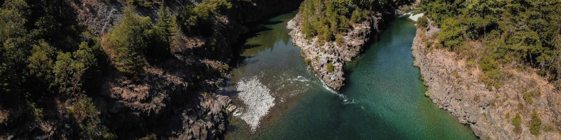
The forest takes its name from six major river systems: the Smith, Klamath, Trinity, Eel, Van Duzen, and Mad Rivers. These waterways drain 1,500 miles of permanent streams that provide nine percent of California's total runoff. The Smith River, managed as the Smith River National Recreation Area in the Gasquet district, holds the distinction of being California's last undammed river.
Four wilderness areas — Siskiyou, Trinity Alps, Yolla-Bolly, and Marble Mountain — are shared with neighboring forests, while Six Rivers has sole management of the smaller Lassics and North Fork wilderness areas. The forest also protects six botanical areas that harbor rare plant communities.
This isn't the Sierra Nevada. The Klamath Mountains are older, more complex geologically, with serpentine soils and scattered peaks rather than a single dramatic spine. Expect dense forests of Douglas fir, tan oak, and madrone at middle elevations, with Brewer's spruce and red fir higher up.
Getting There
The forest spreads across four ranger districts, each with different access points. The Mad River Ranger District sits along Highway 36, about 50 miles east of Highway 101 near Eureka and 100 miles west of Interstate 5. The Lower Trinity district is bisected by Highway 299, connecting the coast to Redding. The Gasquet district, which includes the Smith River area, is reached via Highway 199 north of Crescent City. The Orleans/Ukonom district is accessed primarily through Highway 96, which follows the Klamath River.
From the Bay Area, count on a six-hour drive north. Highway 101 provides the main coastal access, while Interstate 5 serves those approaching from the interior. Highway 299 is the primary east-west connector, though it's a winding mountain road that takes time.
Cell coverage is spotty to nonexistent in much of the forest, particularly in wilderness areas and remote valleys. Don't count on your phone for navigation or emergency communication once you leave the main highways.
When to Go
The forest's size and elevation range create multiple seasons. Lower elevations along the coast are accessible year-round, though winter brings steady rain from November through March. Snow closes higher elevation roads typically from December through April, with exact timing varying by year and location.
The prime season runs from late May through October. Campgrounds operate from May 14 to October 14. Higher elevation trails may remain snow-covered into June, particularly in wilderness areas. July through September offers the most reliable weather, though this is also fire season in dry years.
Fall can be excellent — fewer crowds, stable weather, and fall colors in deciduous areas. Winter has its appeal along the coast for storm watching and river fishing, but much of the high country becomes inaccessible.
Permits & Regulations
Wilderness permits are required for overnight trips in the six wilderness areas. Contact the appropriate ranger district for current quota information and reservation procedures. Day use typically doesn't require permits, but check with specific districts as regulations can vary by area.
Christmas tree permits cost $10 each, with a household limit of two tags, though one person can purchase up to five permits. Personal use rock permits are required for removing rocks and are available through district offices. These permits work across Northern California national forests and Bureau of Land Management lands.
Fire restrictions vary by season and conditions. Wood and open flame rules differ in wilderness areas from general forest areas. The Smith River National Recreation Area prohibits all mineral extraction.
Hiking & Routes
The forest's 250 miles of trails range from easy interpretive walks to multi-day wilderness routes. Elevation gains span from 16 feet to over 7,000 feet.
For day hiking, the Myrtle Creek Trail offers an easy 2.1-mile interpretive route following a historic mining flume. The Island Lake Trail provides a serious workout — 2,000 feet of elevation gain over four miles through old-growth fir to reach an alpine lake.
The Doe Flat Trail to Devil's Punchbowl climbs 8.9 miles into the Siskiyou Wilderness, accessing two alpine lakes via steep switchbacks. It's rated highly for both day hiking and overnight camping. The Raspberry Lake Trail, also in the Siskiyou, covers 7.2 miles with 1,000 feet of elevation gain — more moderate terrain.
Backpackers have extensive options. The South Kelsey Trail follows the scenic South Fork Smith River with excellent riverside campsites. The Marble Mountain Wilderness, accessible from several trailheads, contains 89 lakes and offers multi-day loop possibilities.
Trail conditions vary widely. The Forest Service can't inspect all trails regularly and relies on user reports. Call (707) 442-1721 for current conditions before heading out on longer trips.
Camping
The forest operates 13 developed campgrounds, with about two-thirds using the Recreation.gov reservation system and the remainder available first-come, first-served. Standard sites include fire rings, tables, and vault or flush toilets. Trailer spaces accommodate up to 35 feet at some locations, 20 feet at others. There's a 14-day occupancy limit.
Panther Flat Campground, 16 miles east of Highway 101 on Highway 199, offers showers — a rarity in the forest. Patrick Creek, 22 miles east on the same route, currently has water issues requiring visitors to bring all water.
Oak Bottom sits 2.3 miles from Highway 96 on Salmon River Road and provides bear-resistant food lockers at each site. It's 2.5 miles from Somes Bar. Fish Lake Campground operates mid-June through September and requires a 12-mile drive on forest roads from Orleans — expect no cell service.
The Nordheimer Group Sites accommodate up to 50 people each but require navigating 13 miles of increasingly narrow roads, including one-lane sections with tight corners and drop-offs. Large RVs aren't recommended.
Dispersed camping is allowed throughout the forest following standard Forest Service rules — 200 feet from water sources, existing roads, and trails. The vast road network (2,500 miles total) provides numerous options for those seeking solitude.
Other Activities
The forest's river systems drive much of the recreation. The Smith, Klamath, and Trinity rivers offer world-class opportunities for rafting, kayaking, and fishing. Salmon, steelhead, and trout runs attract anglers year-round, with seasonal variations based on fish migration patterns.
Ruth Lake, a 13,800-acre reservoir near Mad River Campground, provides conventional lake fishing and water sports. The forest's three national scenic byways offer excellent touring for those who prefer to stay on pavement.
Rock hounding is popular, though personal use permits are required. The area's complex geology produces diverse mineral specimens.
Water, Weather & Hazards
Water availability varies dramatically by season and location. Coastal areas and major river drainages typically have reliable sources, but higher elevation areas can dry up by late summer. Always check current conditions and carry purification methods.
Fire danger peaks in late summer and fall, particularly in interior areas. The coastal influence moderates temperatures near the ocean, but inland valleys can exceed 100°F in summer. Winter storms are intense along the coast — roads can wash out and campgrounds flood.
Black bears are present throughout the forest. Rattlesnakes inhabit lower elevation, drier areas. The forest's remoteness means help is far away — cell service is unreliable, and rescue access is limited in wilderness areas.
Finding Solitude
The forest's size and complexity work in favor of solitude seekers. While areas near Highway 101 and popular campgrounds see steady use, much of the forest receives light visitation. The Mad River and Orleans districts, in particular, offer extensive backcountry with minimal crowds.
Weekdays are dramatically quieter than weekends. Shoulder seasons — late spring and early fall — provide the best combination of good conditions and fewer people. The deeper wilderness areas of the Trinity Alps and Marble Mountains require enough effort to deter casual visitors.
For day hiking, skip the highly-rated trails near major access points. The forest's 250-mile trail system includes many routes that see occasional use. Check with ranger districts for suggestions based on current conditions and your abilities.