Shasta-Trinity National Forest
CA
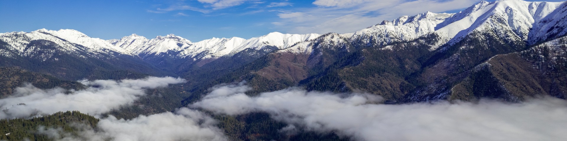
Northern California's Shasta-Trinity spans 2.1 million acres from the Sacramento Valley's edge to the Oregon border — the largest national forest in the state. This isn't one landscape but several: the volcanic cone of 14,162-foot Mount Shasta rising from surrounding plains, the granite spires and alpine lakes of the Trinity Alps, the oak woodlands and rushing rivers of the western slopes. Day hikers come for Castle Crags' dramatic towers, backpackers disappear into the Trinity Alps for weeks, and climbers test themselves on Shasta's glaciated flanks. The forest absorbs crowds across its vastness, offering everything from roadside camping at massive reservoirs to genuine wilderness solitude in places most Californians have never heard of.
Details
- 🏞️Type
- National Forest
- 🏛️Managed by
- USDA Forest Service
- 📍State
- CA
- 🗺️Address
- 3644 Avtech Parkway, Redding, CA, 96002
- 📞Phone
- (530) 226-2500
- 📡GPS
- 40.92111, -122.65292
The Place
Shasta-Trinity sprawls across northern California's most varied terrain, from 1,000-foot oak-studded foothills to Mount Shasta's 14,162-foot summit. The forest encompasses five wilderness areas that feel like separate mountain ranges entirely. The Trinity Alps, California's second-largest wilderness at over 500,000 acres, delivers granite peaks, cirque lakes, and dense forests reminiscent of the Sierra Nevada. Mount Shasta Wilderness protects the massive volcanic cone that dominates the landscape for 100 miles in every direction. Castle Crags offers dramatic granite spires rising abruptly from forested canyons.
The western slopes catch Pacific moisture, supporting dense Douglas fir and mixed conifer forests cut by major rivers: the Trinity, Sacramento, and McCloud. Moving east, the forest transitions to drier ponderosa pine and eventually to the sparse, high-elevation forests around Mount Shasta. The numbers tell the story of this forest's scale: 6,278 miles of streams and rivers, hundreds of mountain lakes, and elevations spanning over 13,000 vertical feet.
Three major reservoirs — Shasta Lake with 365 miles of shoreline, Trinity Lake with 145 miles when full, and smaller Lewiston Lake — add a water recreation dimension absent from most national forests. These aren't pristine alpine lakes but working reservoirs that draw houseboaters, water-skiers, and anglers by the thousands during summer months.
Getting There
The forest surrounds Interstate 5 north of Redding, making access straightforward from the Central Valley. From Sacramento, it's 160 miles north on I-5 to Redding, the primary gateway town with full services and the forest supervisor's office. Mount Shasta city, another 60 miles north on I-5, serves as base camp for the peak and nearby wilderness areas.
Highway 299 cuts east-west through the forest's midsection, connecting Redding to the Trinity Alps region around Weaverville. This winding mountain highway provides access to most Trinity Alps trailheads but demands patience — it's 45 miles and an hour from Redding to Weaverville, longer to reach remote trailheads.
From the Bay Area, expect 4-5 hours to reach most forest destinations. The I-5 corridor maintains cell coverage, but signals fade quickly once you turn onto forest roads. Many trailheads require 5-20 miles of paved but winding mountain roads from the main highways.
Key access roads include Highway 89 north from I-5 to Mount Shasta's eastern slopes, and various forest roads branching from Highway 299 to reach Trinity Alps trailheads. Most passenger cars can reach developed campgrounds and popular trailheads, though some remote areas require high-clearance vehicles.
When to Go
The forest's elevation range creates distinct seasons across different zones. Low-elevation areas around the reservoirs stay accessible year-round, with hot, dry summers reaching well into the 90s. Spring and fall offer the most comfortable weather for hiking these areas.
Most recreation sites operate May 15 through September 15, though dates shift based on snowpack. The Trinity Alps typically remain snow-bound until late June or July at higher elevations, while trails below 5,000 feet may clear by May. Mount Shasta climbing season runs roughly June through September, though the mountain attracts winter climbers willing to deal with technical conditions.
Fire season typically begins in mid-to-late summer, bringing campfire restrictions and potential area closures. September and early October provide excellent hiking weather with fewer crowds, but fire danger often remains elevated. Snow begins falling at higher elevations by November, and skis or snowshoes may be necessary for mountain access through June.
The sweet spot for most activities falls between late June and early September, when high-country access opens and weather remains stable. July through August see peak crowds at popular destinations like Mount Shasta and major Trinity Alps trailheads.
Permits & Regulations
Two of the five wilderness areas require overnight permits: Trinity Alps and Mount Shasta. Both offer self-service permits available at ranger stations and trailheads at no cost. Group size limits hold at 10 people maximum.
Mount Shasta requires a separate Summit Pass for climbs above 10,000 feet, costing $25 per person for three days from purchase. This fee applies only to summit attempts, not general wilderness use below timberline.
Trinity Alps permits are available at Weaverville Ranger Station kiosks and other locations. No quotas exist, but permits help managers track use patterns. The system relies heavily on self-service stations at trailheads.
California Campfire Permits are required for any stove or fire use throughout the forest, available free from ranger stations, CAL FIRE offices, or online. During fire season restrictions, permits may prohibit open fires entirely while still allowing stoves in certain areas.
The three remaining wilderness areas — Castle Crags, Chanchelulla, and Yolla Bolly-Middle Eel — require no wilderness permits for overnight use, just campfire permits.
No Adventure Pass requirements exist for Shasta-Trinity, unlike some southern California forests.
Hiking & Routes
The Pacific Crest Trail crosses 154 miles of the forest from Castle Crags north to the Oregon border, offering everything from roadside access to remote wilderness sections. The Sisson-Callahan National Recreation Trail provides a 10-mile showcase route crossing Deadfall Summit at 8,020 feet with views of Mount Shasta.
Mount Shasta's Avalanche Gulch route represents the forest's most famous challenge: 10.4 miles with 7,214 feet of elevation gain to California's second-highest peak. No maintained trail exists — climbers follow a mountaineering route requiring basic glacier travel skills above 12,000 feet. Horse Camp at 7,900 feet provides a traditional base camp with seasonal water and shelter, though the Sierra Club charges $5 per tent.
Trinity Alps Wilderness offers over 600 miles of trails across terrain ranging from 2,000 feet in creek drainages to 9,000-foot summits. The 13-mile trail to Emerald and Sapphire Lakes ranks among the wilderness's most popular backpacking destinations. Big and Little Boulder Lake Trail provides an easier 2-mile introduction to the area's alpine scenery.
Castle Crags Wilderness, despite its small size, delivers dramatic granite climbing and hiking just off Interstate 5. The area requires no wilderness permit and offers day hiking access to spectacular rock formations.
Trail conditions vary dramatically by season and elevation. Many Trinity Alps routes cross creek drainages that run high during snowmelt, potentially requiring ford strategies. Mount Shasta routes may require mountaineering equipment depending on snow conditions and objectives above timberline.
Camping
Fifty-one developed campgrounds scattered across the forest offer varying levels of amenities. Major reservoir areas provide the most developed camping, often requiring reservations through Recreation.gov during peak season. Some campgrounds operate first-come, first-served, including McCloud Bridge where visitors must be physically present to claim sites.
Antlers Campground, 25 miles north of Redding, sits on a bluff overlooking Shasta Lake but provides no direct lake access. Facilities include flush and vault toilets with drinking water but no hookups or dump stations. Stoney Group Campground on Trinity Lake accommodates up to 60 people with tents.
Camping limits apply forest-wide: 14 days maximum at developed campgrounds, 30 days per year for dispersed camping. Most campgrounds operate seasonally from May through September, with exact dates depending on weather and road conditions.
Dispersed camping is permitted throughout most of the forest following standard rules: camp at least 200 feet from water sources, trails, and roads, and quarter-mile from developed campgrounds. Campfire permits are required for any flame or stove use at dispersed sites. Some areas, including around Lewiston Lake, prohibit dispersed camping entirely.
Trinity Alps and Mount Shasta wilderness areas allow backcountry camping with proper permits. Water availability varies seasonally, particularly in the Trinity Alps where late-season camping may require carrying water between reliable sources.
Other Activities
Shasta, Trinity, and Lewiston lakes support extensive water recreation including boating, water-skiing, swimming, and fishing. Trinity Lake holds 2.5 million acre-feet when full, creating opportunities for multi-day houseboat trips and extensive shoreline exploration.
Mount Shasta attracts serious mountaineers year-round, with multiple routes of varying technical difficulty. Winter climbing requires advanced skills and equipment, while summer routes remain accessible to strong hikers with basic mountaineering knowledge.
The forest's lower elevations offer mountain biking opportunities on forest roads and designated trails, though most single-track trails in wilderness areas remain closed to bikes. OHV use occurs in designated areas, primarily outside wilderness boundaries.
Fishing opportunities span from high-mountain lake angling in the Trinity Alps to major river systems supporting salmon and steelhead runs. The McCloud River system, in particular, attracts fly fishermen to its cold, clear waters.
Water, Weather & Hazards
Water availability varies dramatically by location and season. Trinity Alps lakes and streams typically flow year-round, but late-season hikers should verify conditions as some sources disappear by October. Mount Shasta offers limited water above treeline, though Horse Camp provides a reliable spring once snow melts, usually by June.
Fire danger increases through summer months, with restrictions typically beginning in June or July depending on conditions. Lightning strikes occur regularly during afternoon thunderstorms, particularly dangerous on exposed peaks like Mount Shasta.
Heat becomes a serious factor at lower elevations during summer months, with temperatures often exceeding 100°F around the reservoirs. Afternoon thunderstorms can develop rapidly in mountain areas, creating flash flood risks in drainage channels.
Black bears inhabit the forest but encounters remain relatively uncommon with proper food storage. Rattlesnakes occur at lower elevations, particularly in oak woodland areas during warmer months.
Mount Shasta presents specific hazards including altitude sickness, glacier travel risks above 12,000 feet, and rapidly changing weather conditions. The mountain's prominence means weather can deteriorate quickly regardless of valley conditions.
Finding Solitude
Popular destinations like Mount Shasta's Avalanche Gulch route and major Trinity Alps lakes see heavy use during peak season weekends. Weekday visits dramatically reduce crowds at most locations.
The forest's size works in solitude-seekers' favor. While Mount Shasta and the most accessible Trinity Alps areas draw crowds, vast sections of the forest see minimal visitation. Yolla Bolly-Middle Eel and Chanchelulla wilderness areas offer genuine isolation, partly due to their remote access and limited promotion.
Eastern approaches to the Trinity Alps, particularly from Coffee Creek Road, typically see fewer visitors than the more accessible western trailheads near Weaverville. Similarly, Mount Shasta's less popular routes — Clear Creek, Brewer Creek, and North Gate — attract far fewer climbers than Avalanche Gulch.
Late season, particularly September and early October, provides the best balance of good weather and reduced crowds before winter storms arrive. Early season can work too, but snow conditions limit access to higher elevations well into summer most years.