Sequoia National Forest
CA
The largest national forest in California sprawls across 1.1 million acres of the southern Sierra Nevada, from rolling oak foothills at 1,000 feet to granite peaks pushing 12,000 feet. This is working forest country where giant sequoias share space with OHV trails, wilderness backpackers cross paths with whitewater rafters, and you can camp beside the Kern River after driving logging roads that see more pickup trucks than Subarus. Three ranger districts manage everything from the world's largest trees to some of the West's best trout water, making this the Sierra Nevada for people who want options beyond the crowded national parks next door.
Details
- 🏞️Type
- National Forest
- 🏛️Managed by
- USDA Forest Service
- 📍State
- CA
- 🗺️Address
- 1839 South Newcomb Street, Porterville, CA, 93257
- 📞Phone
- (559) 784-1500
- 📡GPS
- 36.01567, -118.39294
The Place
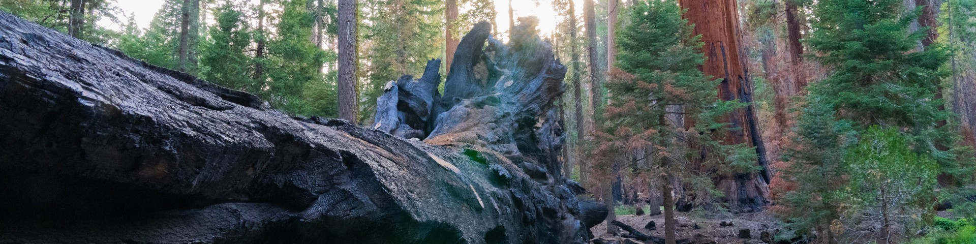
Sequoia National Forest divides cleanly into three worlds. The western foothills roll in oak-studded grassland and chaparral, cut by the Wild and Scenic Kings River and its granite gorges. The middle country rises through mixed conifer forests studded with 30-plus giant sequoia groves, including those protected within the 328,315-acre Giant Sequoia National Monument. The high country pushes into alpine granite, with six wilderness areas totaling over 314,000 acres.
The Golden Trout Wilderness alone covers 303,287 acres across two national forests, protecting meadows and lakes from 4,800 to 12,000 feet where California's state fish still swims in native waters. The Domeland Wilderness offers a different flavor — 94,695 acres of weathered granite domes and desert-mountain transition zone. Jennie Lakes Wilderness provides nearly 11,000 acres of accessible backcountry with 26 miles of trails connecting to both Sequoia and Kings Canyon national parks.
Water defines much of the forest's character. The Kern River cuts through the southern section as a federally designated Wild and Scenic River, creating world-class whitewater and some of California's best trout habitat. Add 2,617 other rivers and streams, plus 158 ponds and lakes, and you have a forest where finding water is rarely the problem — timing your visit for the right flows is.
Getting There
Three ranger districts provide different entry points. The Hume Lake Ranger District covers the northern section east of Fresno, accessible via Highway 180 through Kings Canyon National Park or Highway 245 from the San Joaquin Valley. The Western Divide Ranger District sits just east of Springville off Highway 190. The Kern River Ranger District anchors the southern end near Lake Isabella via Highway 178 or Highway 155.
From Los Angeles, expect 3-4 hours to reach the Kern River area via Interstate 5 north to Highway 99, then Highway 178 east through Bakersfield. From the Bay Area, the Hume Lake district is about 4 hours via Highway 180 east from Fresno. Cell coverage varies dramatically — count on service near developed areas and major highways, but plan for dead zones in wilderness areas and remote forest roads.
The Generals Highway provides the scenic connection between districts, though winter closures are common above 5,000 feet. Many forest roads require high-clearance vehicles, and some close entirely in winter.
When to Go
The 11,000-foot elevation range means somewhere in this forest is always accessible, but timing matters. The foothills stay open year-round but bake in summer — think 100-degree days from June through September. The middle elevations around 4,000-7,000 feet offer the best shoulder seasons: April-May and September-October provide mild days and cool nights without summer crowds or winter closures.
The high country operates on Sierra Nevada time. Snow lingers until June at higher elevations, and the Trail of 100 Giants at 6,400 feet typically opens late May through November 30. Pacific Crest Trail sections above 8,000 feet may be snow-covered into July in heavy snow years.
Fire season runs June through October, with restrictions tightening as conditions worsen. Summer thunderstorms are common in the high country, creating afternoon lightning danger. Late fall and early winter offer surprisingly good hiking weather in the middle elevations, though services may be reduced.
Permits & Regulations
The permit situation splits along wilderness boundaries. Golden Trout Wilderness requires permits for overnight stays — obtain them at least 30 days prior to travel. Other wilderness areas within Sequoia National Forest don't require overnight permits when accessed from forest trailheads, though permits issued by Sequoia and Kings Canyon national parks are valid for continuous travel into adjacent forest wilderness.
Parking fees apply at select locations: $12 cash only, including at the Trail of 100 Giants. No general forest entry fee exists, unlike the neighboring national parks.
Fire permits are required for campfires and camp stoves outside developed campgrounds during fire season. Get them free from any ranger station or online. Campfire restrictions vary by elevation and season — higher elevations typically allow fires longer into the season.
Adventure Pass requirements weren't specified in the available information, so check with individual ranger districts for current regulations.
Hiking & Routes
More than 1,147 miles of trails range from paved loops to multi-day wilderness routes. The Pacific Crest Trail crosses 47 miles of forest, offering everything from foothill oak woodland to alpine granite.
The Trail of 100 Giants provides the easiest introduction — a 1.4-mile paved loop at 6,400 feet showcasing giant sequoias. More challenging day hikes include Little Baldy Trail (3.3 miles, 800 feet gain) and Tokopah Falls Trail (4.0 miles, 616 feet gain) leading to a 1,200-foot waterfall most impressive in spring.
Weaver Lake Trail stretches 6.7 miles with 1,233 feet of elevation gain, earning 4.8 stars from over 1,400 reviewers. Three National Recreation Trails — Summit, Cannell Meadow, and Jackass Creek — offer maintained routes with varied difficulty.
The Golden Trout Wilderness provides the most remote backpacking, with elevations from 4,800 to 12,000 feet protecting pristine lakes and meadows. The Jennie Lakes Wilderness offers more accessible multi-day options with connections to the national parks.
Monarch Wilderness splits nearly evenly between Sequoia and Sierra national forests, starting around 2,000 feet along the Wild and Scenic South Fork Kings River and climbing through diverse ecosystems.
Camping
Fifty-two developed campgrounds spread across the forest's elevation zones. Reservation-based campgrounds like Stony Creek (nearly 50 sites at 6,500 feet) and Upper Stony Creek (17 sites, also at 6,500 feet) require Recreation.gov bookings, especially for peak season visits.
The Kern River Ranger District alone offers 25 campgrounds and 10 day-use areas. Headquarters Campground sits at 2,800 feet overlooking the Kern Wild and Scenic River, 4 miles north of Kernville. Higher elevation options include sites at 7,500-7,600 feet.
Extra vehicle fees run $8 per night for second vehicles in single sites and third or fourth vehicles in double sites. Standard 14-day camping limits apply within any 30-day period.
Dispersed camping is allowed throughout most of the forest outside wilderness areas and developed campgrounds, though specific restrictions may apply during fire season or in sensitive areas.
Other Activities
The Kern River system delivers world-class whitewater rafting, from Class III-IV runs perfect for intermediate paddlers to expert-only sections. The Upper Kern River supports wild Kern River rainbow trout, a subspecies found nowhere else.
Over 1,500 miles of maintained roads serve OHV users, plus 1,000 miles of abandoned roads available for exploration. This forest accommodates serious off-highway vehicle recreation in designated areas.
Horseback riders and pack stock have access to wilderness areas and many forest trails. The 850 miles of trails accommodate multiple user groups, though specific trail restrictions apply.
Water, Weather & Hazards
Water availability varies dramatically by season and elevation. High country streams run strong during snowmelt but may reduce to trickles by late summer. Always check current conditions and carry extra water capacity.
Black bears are common throughout the forest — use bear canisters in wilderness areas and proper food storage elsewhere. Rattlesnakes inhabit lower and middle elevations, especially during warmer months.
Fire danger peaks in late summer and early fall, when dry conditions and hot Diablo winds create extreme risk. Lightning-caused fires are common during summer thunderstorm season.
The elevation range creates multiple weather patterns simultaneously. Foothill areas may reach 100 degrees while high country experiences afternoon thunderstorms and possible snow. Always check weather for your specific elevation range.
Finding Solitude
The Giant Sequoia National Monument draws crowds to iconic groves, but 30-plus other sequoia groves receive far fewer visitors. The southern and eastern wilderness areas — Golden Trout, South Sierra, and Domeland — see a fraction of the traffic compared to areas near the national parks.
Weekdays and shoulder seasons (April-May, September-October) offer the best odds for solitude. The 314,000-plus wilderness acres provide plenty of space, but access requires longer approaches and wilderness permits for some areas.
Winter and early spring transform the forest. Snow closes high-elevation roads but opens cross-country skiing and snowshoeing opportunities with virtually no crowds. The foothill areas offer surprising winter hiking when the high country is locked in snow.