San Bernardino National Forest
CA
San Bernardino National Forest sprawls across 823,816 acres of Southern California mountain country, making it the closest substantial wilderness to some 20 million people. This proximity breeds both opportunity and chaos — you can be hiking through pine forests at 10,000 feet within two hours of downtown LA, but you'll share popular trails with half the Inland Empire on weekends. The forest splits into two distinct mountain ranges: the San Bernardino and San Gabriel ranges to the north, and the San Jacinto and Santa Rosa ranges to the south, each offering vastly different experiences from desert washes to subalpine meadows.
Details
- 🏞️Type
- National Forest
- 🏛️Managed by
- USDA Forest Service
- 📍State
- CA
- 🗺️Address
- 602 S. Tippecanoe Avenue, San Bernardino, CA, 92408
- 📞Phone
- (909) 382-2600
- 📡GPS
- 34.08989, -117.26225
The Place
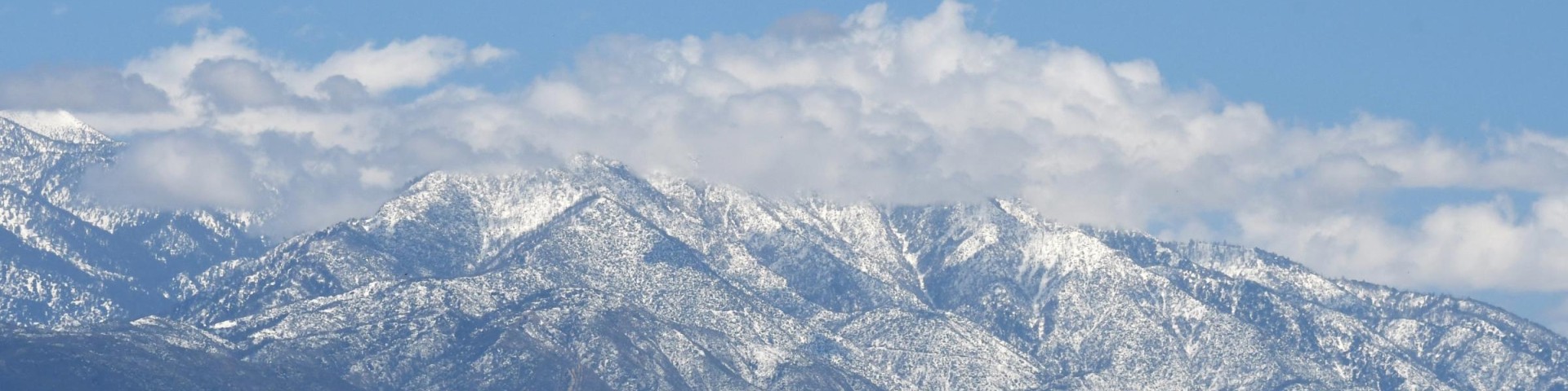
The forest's 823,816 acres stretch from desert floors at 2,000 feet to 11,503 feet atop San Gorgonio Mountain, Southern California's highest peak. This massive elevation range creates distinct ecosystems stacked vertically: chaparral and oak woodlands give way to pine and fir forests, which yield to sparse subalpine zones near the summits.
Eight designated wilderness areas preserve the forest's wild core, totaling over 300,000 acres. San Gorgonio Wilderness protects the approaches to "Old Grayback," while San Jacinto Wilderness encompasses 32,248 acres around the desert-facing escarpment. Cucamonga Wilderness guards the rugged front range visible from the San Gabriel Valley. The remaining areas — Cahuilla Mountain, South Fork San Jacinto, Sheep Mountain, Santa Rosa, and Bighorn Mountain — offer progressively fewer crowds as their names become less familiar.
Seven wild and scenic rivers cut through the mountains, though "river" overstates most of these seasonal waterways. The Santa Ana River system drains the northern ranges, while various desert washes handle runoff from the southern peaks. Don't expect reliable water sources outside of developed areas.
Four ski resorts operate on the forest — Snow Summit, Snow Valley, Mountain High, and Mt. Baldy — transforming winter slopes into summer mountain biking venues. The 2,650-mile Pacific Crest Trail traverses both mountain ranges, creating one of the few through-hiking opportunities that doesn't require wilderness permits for the trail itself.
Getting There
The forest wraps around the greater Los Angeles metropolitan area, creating multiple access points. From the west, Interstate 210 and State Route 2 (Angeles Crest Highway) provide primary access to the San Gabriel Mountains section. The San Bernardino Mountains are best reached via Interstate 10 to State Route 330 (Mountain Road) or State Route 18 (Rim of the World Highway).
For the southern ranges, Interstate 10 through Cabazon leads to State Route 243, the primary route into Idyllwild and San Jacinto Mountains access. Palm Springs serves as the gateway for desert-side approaches via the Palm Springs Aerial Tramway or various desert wash routes.
Distances from major cities: Los Angeles (60-120 miles depending on destination), San Diego (100-150 miles), Las Vegas (200-250 miles). Weekend traffic from these population centers can double drive times, particularly on State Route 330 and through the Cajon Pass.
Many backcountry roads require high-clearance or four-wheel-drive vehicles. Forest roads leading to dispersed camping areas and remote trailheads often deteriorate rapidly after storms. Cell coverage varies dramatically — reliable in developed areas and along major ridgelines, spotty to nonexistent in canyons and wilderness areas.
When to Go
The forest's elevation range creates distinct seasonal zones. Lower elevations below 5,000 feet offer year-round hiking, though summers bring triple-digit temperatures that make early morning starts essential. Fall through spring provides ideal weather for desert transition zones and chaparral country.
Upper elevations above 7,000 feet see snow from December through March, sometimes into May on north-facing slopes. Summer months offer the only reliable access to high country destinations like San Gorgonio and San Bernardino peaks. July through September brings afternoon thunderstorms to high peaks — plan alpine starts for safety.
Fire season typically runs May through October, with peak danger in September and October when Santa Ana winds combine with drought conditions. Campfire restrictions often begin in May and can extend through November depending on conditions.
Many campgrounds operate seasonally from May through October, closing when snow blocks access roads. Higher elevation facilities like those around Lake Arrowhead close earliest, while desert-adjacent campgrounds may remain accessible year-round.
Permits & Regulations
All vehicles parked in developed forest areas require an Adventure Pass — $5 daily or $30 annually (covers a second vehicle for an additional $5). This covers 100+ sites across four Southern California national forests and funds facilities maintenance. Purchase online or at most outdoor retailers.
Wilderness permits are required for all day hiking and overnight camping in the San Gorgonio, Cucamonga, and San Jacinto wilderness areas. Permits are free but must be obtained online in advance. The system allows reservations up to 90 days ahead for peak summer periods. Popular routes like San Gorgonio via Vivian Creek and San Bernardino Peak fill months in advance for summer weekends.
The Devil's Slide Trail to San Jacinto Peak operates under a quota system from Memorial Day weekend through Labor Day weekend, limiting daily entries to protect the heavily-used route. For San Jacinto area permits, contact the Idyllwild Ranger Station at (909) 382-2921.
California campfire permits are mandatory for all fire use, including gas stoves and lanterns. These free permits are available online and remain valid for one year. Campfires are prohibited in all wilderness areas regardless of permit status.
Dispersed camping allows stays up to 14 days within any 30-day period. Personal property cannot remain unattended for more than 10 days. Popular dispersed areas often develop informal "hosts" who monitor compliance and assist newcomers.
Hiking & Routes
The forest's 300 miles of trails range from gentle nature walks to brutal peak climbs. San Gorgonio Mountain via Vivian Creek represents the classic Southern California peak bagging experience — 8 miles one-way gaining over 5,000 feet to the state's highest summit outside the Sierra Nevada. The route starts in oak chaparral and climbs through every life zone to sparse subalpine forest.
San Bernardino Peak offers similar challenges with different rewards. The 15-mile round-trip from Angelus Oaks climbs 4,700 feet to 10,649-foot views across the entire region. The trail starts at 5,960 feet, making it slightly more forgiving than San Gorgonio approaches.
For less punishing options, the Pacific Crest Trail provides excellent segments for day hiking or overnight trips without wilderness permits (though camping off-trail still requires permits in wilderness areas). The PCT through Deep Creek offers rare year-round water and natural hot springs, though the access road demands high-clearance vehicles.
Pine Knot Trail near Big Bear Lake climbs 2.5 miles to Grand View Point at 7,784 feet, offering expansive vistas for modest effort. This makes an excellent introduction to the forest's high country.
Desert-facing routes present different challenges. The Palm Springs Aerial Tramway deposits hikers at 8,516 feet for access to San Jacinto Peak via a relatively gentle 5.5-mile route. This eliminates the brutal elevation gain from desert floor but creates crowds and requires tram tickets ($30+ per person).
Lower elevation trails shine during winter months. The Santa Ana River Trail system provides flat, accessible hiking through riparian zones, while various nature trails around developed campgrounds offer family-friendly options.
Camping
Thirty-nine developed campgrounds provide the majority of overnight options, from full-service RV facilities to basic tent sites. Reservations through Recreation.gov are essential for summer weekends and recommended year-round for popular locations. Most sites require 48-hour advance booking.
Serrano Campground at Lake Gregory offers over 100 sites including full RV hookups and a dump station for an additional $10 fee. Barton Flats, located 36 miles northeast of San Bernardino, operates on reservations only with no first-come sites. The campground lacks hookups but provides paved RV pads and dump station access.
North Shore Family Campground near Lake Arrowhead splits between 22 reservable sites and 6 first-come opportunities. Big Pine Flat Family Campground sits at 6,820 feet elevation in dense pine forest, offering cooler summer temperatures.
Dispersed camping provides free alternatives throughout the forest, though high-clearance vehicles are often necessary to reach suitable sites. Popular areas include various forest roads off State Route 38 and backcountry routes throughout the San Bernardino Mountains.
Developed campgrounds typically charge $8 for each additional vehicle beyond the first. Most sites accommodate up to 8 people and 2 vehicles without extra fees.
Other Activities
Mountain biking thrives on the forest's extensive road system and designated trail networks. Hundreds of miles of forest roads provide legal riding opportunities, while specific trail systems cater to various skill levels. Many ski areas convert to mountain bike parks during summer months.
Equestrian use remains significant with 100+ miles of designated horse trails and specialized equine camping facilities. Several campgrounds provide horse corrals and water access designed for stock users.
OHV enthusiasts find designated areas throughout the forest, though wilderness boundaries and seasonal closures limit access. Popular OHV areas concentrate in the northern sections away from major population centers.
Four downhill ski resorts operate during winter months, typically December through March depending on snowfall. Cross-country skiing and snowshoeing opportunities expand throughout high elevation areas when snow conditions permit.
Fishing occurs in scattered lakes and seasonal streams, though reliable water sources are limited. Lake Arrowhead, Big Bear Lake, and various smaller reservoirs provide the most consistent opportunities.
Water, Weather & Hazards
Water scarcity defines much of the forest experience. Reliable sources concentrate around developed areas and certain creek drainages, but most trails require carrying all water needed. Summer temperatures can exceed 100°F at lower elevations, making hydration critical.
High elevation areas face typical mountain weather patterns — afternoon thunderstorms during summer months, snow from December through March, and rapid temperature changes year-round. Lightning strikes pose serious risks on exposed ridges and peaks.
Fire danger peaks during fall months when Santa Ana winds combine with drought conditions. These hot, dry winds can rapidly spread wildfires and create dangerous driving conditions on exposed mountain roads.
Black bears inhabit most of the forest, particularly around campgrounds and picnic areas. Proper food storage in bear boxes or bear canisters is mandatory in wilderness areas and recommended throughout the forest.
Rattlesnakes remain active from March through October at lower elevations. Most encounters occur when hikers surprise snakes on warm rocks or in brush. Standard precautions include watching where you step and avoiding reaching into blind areas.
Mountain lions, while present, rarely interact with humans. The more significant hazard comes from domestic dogs off-leash, which can trigger defensive behavior from wildlife or become lost in rugged terrain.
Finding Solitude
Popular destinations like San Gorgonio Mountain, San Bernardino Peak, and easily accessible PCT segments attract crowds that would surprise visitors expecting wilderness solitude. Summer weekends can resemble urban trail systems near major trailheads.
Timing offers the best escape strategy. Weekday visits, particularly Tuesday through Thursday, provide dramatically different experiences. Early morning starts help avoid both crowds and afternoon heat at lower elevations.
Lesser-known wilderness areas like Cahuilla Mountain, Sheep Mountain, and portions of Santa Rosa Wilderness see fraction of the traffic despite offering equally scenic experiences. The trade-off involves longer approach drives and less developed trail infrastructure.
Winter conditions naturally limit crowds in high country while creating excellent opportunities for snowshoe and ski touring. Lower elevation areas during summer weekdays often provide surprising solitude despite proximity to major population centers.
Dispersed camping areas away from major forest roads offer the best chance for quiet nights, though they require self-sufficiency and appropriate vehicles to access safely.