Modoc National Forest
CA
Modoc National Forest occupies California's far northeastern corner, where volcanic plateaus meet high desert and the Warner Mountains rise from sagebrush country. This is where California begins to feel like Nevada — big skies, wild horses roaming 500 square miles of territory, and trails where you might not see another soul all day. While other Sierra forests draw crowds, Modoc's 1.6 million acres remain largely unknown, attracting hunters, obsidian collectors, and hikers seeking the kind of solitude that's increasingly rare in California's public lands.
Details
- 🏞️Type
- National Forest
- 🏛️Managed by
- USDA Forest Service
- 📍State
- CA
- 🗺️Address
- 800 West 12th Street, Alturas, CA, 96101
- 📞Phone
- (530) 233-5811
- 📡GPS
- 41.72000, -120.76000
The Place
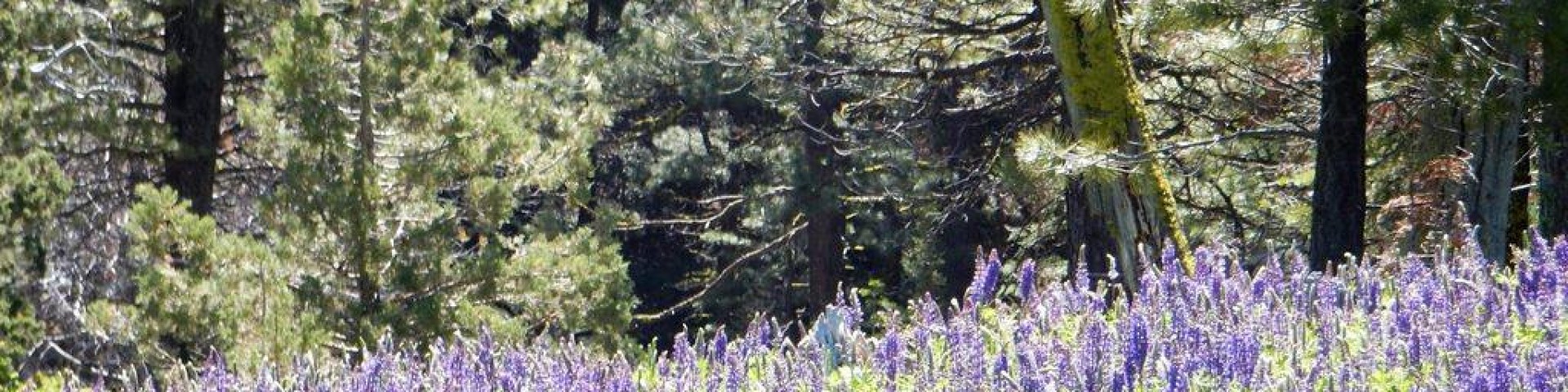
Three distinct landscapes define Modoc: the volcanic Medicine Lake Highlands in the west, the flat Devil's Garden plateau in the center, and the Warner Mountains along the eastern edge. Elevations range from 4,300 feet on Devil's Garden to 7,600 feet in the Warners, creating zones from high desert sagebrush to lodgepole pine and red fir forests.
The Devil's Garden plateau dominates the central forest, rolling fairly flat between 4,300 and 5,400 feet. This is classic Great Basin country — juniper, sagebrush, and scattered ponderosa pine, punctuated by seasonal lakes and meadows. The plateau hosts the largest wild horse territory in the Forest Service system, where 200-400 horses roam freely across a quarter-million acres.
To the west, the Medicine Lake Highlands rise into volcanic terrain with lodgepole pine and red fir forests reaching 7,000 feet. This area connects to Lava Beds National Monument and offers the forest's most developed recreation infrastructure around Medicine Lake itself.
The Warner Mountains form the forest's eastern spine, climbing to 7,600 feet with mixed conifers, alpine meadows, and numerous lakes. The South Warner Wilderness protects the range's high country, offering hundreds of miles of trails through terrain that sees few visitors outside hunting season.
Three ranger districts divide management: Big Valley encompasses areas around Adin in a crescent shape, Doublehead covers the higher elevation western forests, and Warner Mountain manages the eastern ranges with their hiking and wilderness opportunities.
Getting There
Alturas serves as the forest's primary gateway, sitting at the junction of US 395 and CA 299. The forest headquarters operates here, issuing obsidian permits and providing current conditions. From Reno, it's 120 miles north on US 395. Sacramento requires a longer haul — 250 miles via I-5 to CA 299 east, or US 395 north through the Sierra.
Medicine Lake access runs from McCloud via US 89 south for 16 miles, then Forest Service Road 15 (Harris Spring Road) for 4.4 miles to Road 49. Blue Lake in the Warners requires driving from Alturas south on US 395 to Likely, then County Road 64 (Jess Valley Road) east for 9 miles and Blue Lake Road for another 8.5 miles.
High-clearance vehicles handle most forest roads adequately, but four-wheel drive opens access to remote trailheads, particularly on eastern approaches via County Road 27 (Granger Creek). Roads close when wet enough to create ruts deeper than one foot — not uncommon during spring melt or summer thunderstorms.
Cell coverage remains spotty to nonexistent throughout most of the forest. Plan accordingly.
When to Go
Modoc's seasons split along elevation lines. The Devil's Garden plateau opens earliest, with snow typically gone by April and decent conditions lasting through November. Summer temperatures can push 90°F in the high desert, making spring and fall more comfortable for extended hiking.
Higher elevations in the Medicine Lake Highlands and Warner Mountains see snow from November through May. Blue Lake Campground gets water from late May through early October, indicating the seasonal window for higher elevation access. The best hiking weather in the Warners runs June through September, though late September brings hunting season crowds.
Fire season peaks July through September. California campfire permits — free from Forest Service offices — become mandatory during fire restrictions, which vary annually. Summer thunderstorms can create flash flood conditions on normally dry washes.
Winter transforms accessible areas into snowmobile territory. The Doorknob Warming Hut Snowpark maintains 200 miles of groomed trails, though most forest roads become impassable.
Permits & Regulations
Modoc doesn't require Adventure Pass fees — those apply to southern California forests. Wilderness permits aren't mentioned in available information, suggesting the South Warner Wilderness may not have quota systems like Sierra destinations. Contact the forest office at (530) 233-5811 for current wilderness regulations.
California campfire permits cost nothing but are mandatory during fire restrictions. Get them at the Alturas supervisor's office, any CAL FIRE station, or BLM office. Permits run from issue date through December 31.
Obsidian collecting requires free permits issued at the Alturas office starting July 1, valid through August 31. Daily permit limits apply, with a maximum of three permits per person per season. Collection areas and specific rules come with the permit.
Commercial activities require minimum fees of $115 plus 3% of income generated on forest lands. Tours need $500,000 in liability insurance.
Dispersed camping allows 14 days in any single location and 30 total days per year on the forest. Personal firewood collection needs no permit — limit 2 bushels daily, 6 bushels annually.
Hiking & Routes
Modoc's trail system favors solitude over convenience. Most trails accommodate horses and pack stock, but not all routes are well-marked. The South Warner Wilderness contains the longest and most challenging options.
The Summit Trail represents the forest's premier backpacking route. From Pepperdine Trailhead to Patterson Lake, it runs 11.8 miles with 2,467 feet of elevation gain. The full trail extends 22.4 miles with 3,805 feet of total ascent — the forest's longest and most elevation-intensive route. This trail accesses the Warner Mountains' high country and consistently rates highest among visitors.
Mill Creek Falls provides the most popular day hike — under one mile round-trip with minimal elevation gain. It offers an easy introduction to the forest without requiring significant planning or fitness.
Blue Lake features a 3-mile loop trail around the lake, plus a 3-mile uphill trail to the upper trailhead gaining 790 feet. Several wilderness trailheads sit within 6-15 miles of the campground, making it a logical base for South Warner exploration.
Recent trail maintenance covers Cedar Creek Trail, Red Tail Rim Trail, Pit River Trail, Medicine Lake Highlands trails, and all South Warner Wilderness routes. However, approach roads to some trailheads require high-clearance or four-wheel-drive vehicles.
The forest offers hundreds of miles of trails including multiple loop options in the South Warner Wilderness, where encounters with other hikers remain rare even during peak season.
Camping
Three campgrounds accept reservations through Recreation.gov, while others operate first-come, first-served. Medicine Lake Recreation Area provides the most developed camping with 86 sites across five loops: Medicine, A.H. Hogue, Hemlock, Headquarters, and Schonchin Springs. Only 15 sites in Medicine and A.H. Hogue loops accept advance reservations. Each site includes picnic table, fire ring, and barbecue grill. Note that tribal gatherings close Medicine and Hogue loops to public use July 15-21 annually.
Blue Lake Campground offers 48 large, well-spaced sites with paved roads and water available late May through early October. The campground provides group site reservations and serves as a gateway to South Warner Wilderness trailheads.
Other developed campgrounds include Big Sage Reservoir near the boat ramp, Ash Creek at lower elevation for earlier season access, and Cave Lake, which sees heaviest use during fall deer hunting. All feature pit toilets, fire rings, and picnic tables with varying water availability.
Dispersed camping follows standard Forest Service rules: 14 days maximum per location, 30 days total annually. The Devil's Garden plateau offers numerous dispersed opportunities across relatively flat terrain, though water sources can be seasonal.
Reserve popular campgrounds months in advance for summer weekends. Book through Recreation.gov or (877) 444-6777.
Other Activities
Wild horse viewing dominates unique opportunities here. The 500-square-mile Devil's Garden Wild Horse Territory near Alturas hosts the Forest Service's largest wild horse population. The forest maintains 206-402 horses through periodic gather operations.
Obsidian collecting attracts rockhounds during the July-August season. Free permits from Alturas headquarters allow collection in designated areas with daily and seasonal limits.
Off-highway vehicle use finds extensive opportunities across the plateau country, though specific designated routes aren't detailed in available information.
Winter brings extensive snowmobiling. The Doorknob Warming Hut Snowpark grooms 200 miles of trails, transforming the forest into northeastern California's premier snowmobile destination.
Fishing opportunities exist around Blue Lake and other high-country waters, though specific regulations and seasons require checking with California Department of Fish and Wildlife.
Water, Weather & Hazards
Water availability varies dramatically by season and elevation. High-country sources like Blue Lake maintain water late May through early October, while lower elevation seasonal lakes and creeks can dry completely by midsummer. Carry water or purification for all hiking, particularly on the plateau.
Summer thunderstorms create flash flood potential in normally dry washes. Lightning poses serious risk on exposed ridges and peaks during afternoon storms.
Fire danger peaks July through September. The combination of dry conditions, frequent lightning, and limited access can create rapidly changing situations. Check current restrictions before any visit.
Wildlife includes black bears, though encounters are less common than in Sierra forests. Rattlesnakes inhabit lower elevations, particularly around rocky areas and water sources.
Winter weather can change rapidly at elevation. Even late spring and early fall can bring unexpected snow above 6,000 feet.
Finding Solitude
Modoc's remoteness provides natural crowd control. Most visitors concentrate around Medicine Lake Recreation Area and Blue Lake Campground during summer months. The South Warner Wilderness sees hunting pressure in fall but remains quiet spring through early fall.
Mid-week visits eliminate most recreational users. Even popular areas like the Mill Creek Falls trail see light use compared to destinations in more accessible forests.
The Devil's Garden plateau offers vast opportunities for solitude, though the flat terrain and limited water require more planning. Eastern approaches via rough roads filter out casual visitors, providing access to trailheads that see minimal use.
Spring and late fall provide the quietest periods, when most visitors avoid potentially unsettled weather but conditions remain generally favorable for hiking and camping.
Choose lesser-known campgrounds like Cave Lake or Ash Creek over the developed Medicine Lake facilities. These areas provide basic amenities while avoiding the concentration of users at primary destinations.