Klamath National Forest
OR
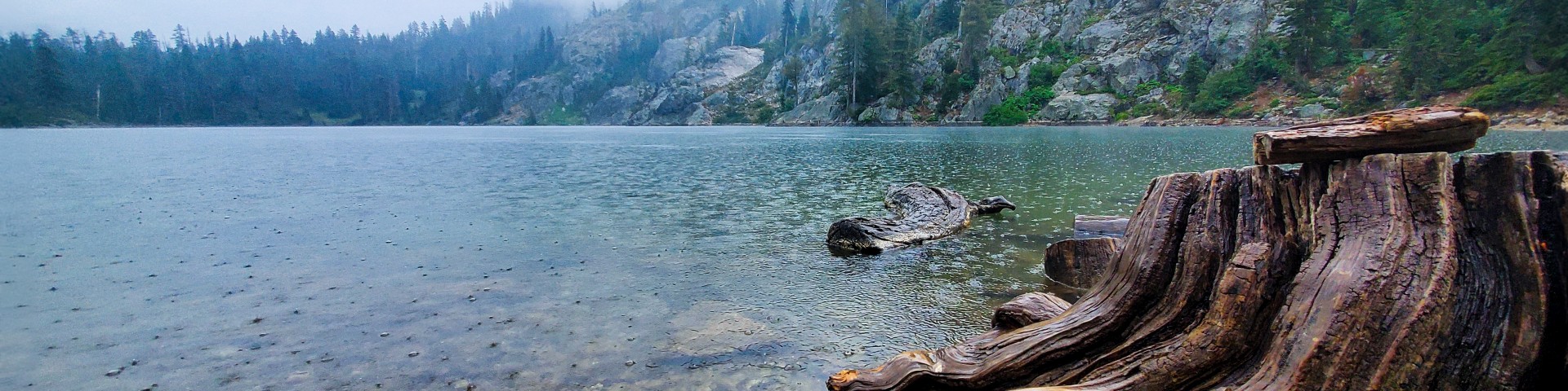
Nearly two million acres of rugged mountains and deep river canyons straddling the California-Oregon border, Klamath National Forest feels like the Pacific Northwest's forgotten stepchild. This is a working forest where serious hikers come for solitude in five wilderness areas, anglers chase steelhead on 152 miles of Wild and Scenic rivers, and OHV riders have 2,800 miles of roads and trails largely to themselves. The terrain ranges from 450 feet along the Klamath River to 8,900-foot peaks in the Marble Mountains, creating a landscape that's part temperate rainforest, part high desert, and entirely uncrowded compared to the Sierra Nevada to the south.
Details
- 🏞️Type
- National Forest
- 🏛️Managed by
- USDA Forest Service
- 📍State
- OR
- 🗺️Address
- 1711 South Main Street, Yreka, OR, 96097
- 📞Phone
- 1111111111
- 📡GPS
- 41.54000, -123.27000
The Place
This is mountain country with an attitude problem. The Klamath Mountains are geologically distinct from both the Cascades and the Sierra Nevada, built from ancient ocean floor that got scraped onto the continent in messy, mineralized chunks. The result is a landscape of steep ridges, narrow valleys, and rivers that carved their channels before the mountains finished rising around them.
Five wilderness areas anchor the forest: Marble Mountain (241,744 acres), Trinity Alps (sharing 38,000 acres with Shasta-Trinity), Russian (12,000 acres), Red Buttes (19,940 acres), and Siskiyou (153,432 acres). Each has its own character. The Marble Mountains live up to their name with white limestone peaks and alpine lakes. The Trinity Alps offer granite spires and cirque lakes that feel like a smaller, quieter Sierra. The Siskiyou Wilderness sprawls across the Oregon border with over 100 miles of trails through old-growth forest and botanical areas that harbor rare plants.
The Klamath River system dominates the western portion of the forest, cutting a deep canyon from the Cascades to the Pacific. The Scott River feeds in from the east. These aren't gentle mountain streams — they're serious whitewater rivers with designated Wild and Scenic status, dropping through Class IV and V rapids in places.
Elevations create distinct zones. Down along the rivers at 450 feet, you're in oak woodlands and chaparral that bake in summer. Climb to 3,000 feet and you hit mixed conifer forest. Above 6,000 feet, the trees thin to subalpine fir and mountain hemlock. The highest peaks barely scratch 8,900 feet, but they feel bigger due to the dramatic relief from the river canyons.
Getting There
Yreka serves as the forest headquarters and main supply town, sitting right on Interstate 5 about 280 miles north of San Francisco and 50 miles south of Medford, Oregon. From Yreka, Highway 3 heads west into the heart of the forest, passing Fort Jones and Etna before reaching the Marble Mountain Wilderness trailheads.
For the western sections and Klamath River access, take Highway 96 west from I-5 at Yreka. This two-lane road follows the Klamath River through Happy Camp (another ranger station) and connects to numerous forest roads. Highway 263 branches south from 96 to reach the Siskiyou Wilderness.
The forest's eastern boundary runs along I-5 itself, making access easy for PCT hikers. Castle Lake Road and other forest roads branch west from the interstate near Mount Shasta city.
Most forest roads are gravel but suitable for passenger cars in dry conditions. The exceptions are high-elevation access routes that may require high-clearance vehicles and are typically closed by snow from November through May. Forest Road 44N45 to the Marble Mountains and 38N27 to various trailheads can get rough but remain passable for most vehicles.
Cell coverage is spotty to nonexistent once you leave the main highways. The Klamath Mountains effectively block signals, so don't count on GPS navigation or emergency calls from the backcountry.
When to Go
The elevation spread creates a long season if you know where to look. River-level campgrounds and trails are accessible year-round, though winter brings rain that can make unpaved forest roads muddy and potentially impassable.
Spring arrives early at lower elevations, with wildflowers blooming in the foothills by March. But the high country remains snowed in until late June or even July in heavy snow years. This creates ideal conditions for waterfall viewing and comfortable hiking on low-elevation trails while the crowds are still waiting for Sierra snow to melt.
Summer brings fire season, typically running from June through October. Campfire permits become mandatory throughout the forest, and campfire bans are common by midsummer. Temperatures at river level can hit 100°F, but the higher elevations remain pleasant.
Fall might be the best time to visit. Fire danger drops after the first rains, usually in September or October. Crowds thin out as school starts. The weather remains stable, and you can still access high-elevation trailheads before the snow returns.
Winter transforms the forest. The Happy Camp Ranger District maintains 135 miles of cross-country ski trails, and the lower elevations offer hiking opportunities when the rest of the Sierra Nevada is buried. Snow typically closes high-elevation forest roads from November through May, though exact timing varies with the snowpack.
Permits & Regulations
The permit situation is refreshingly straightforward compared to other California forests. Wilderness permits are not required for day hiking or backpacking in the Siskiyou Wilderness, which covers much of the forest's trail system. The Marble Mountain Wilderness also operates without quotas or advance permits for most areas.
However, the Trinity Alps Wilderness requires both wilderness permits and California Campfire Permits. These can be obtained from the Happy Camp Ranger District or other Forest Service offices.
A California Campfire Permit is mandatory forest-wide if you plan to use any fire, stove, or BBQ outside developed campgrounds. These are free and available at any Forest Service or Cal Fire office, or online. During fire season, campfire bans can shut down all open flames, including camp stoves, so check current restrictions.
The forest does not require Adventure Passes, unlike many Southern California forests. Standard parking and access is free, though some developed campgrounds and day-use areas charge fees.
Special use permits are required for groups of 75 or more people and for any commercial activities. Applications need to be submitted at least 45 days in advance through the appropriate ranger district.
OHV users have access to over 2,800 miles of forest roads and trails without additional permits beyond vehicle registration, though specific areas may have seasonal closures to protect wildlife or during fire danger.
Hiking & Routes
The trail system here rewards those who venture beyond the PCT. While the Pacific Crest Trail does pass through the forest for 96.3 miles, covering 16,774 feet of elevation gain from Highway 5 to Etna Summit, the wilderness areas hold the real treasures.
In the Marble Mountain Wilderness, the Boulder Creek Trail (Trail #5534) accessed via Forest Road 44N53Y leads to several alpine lakes. The terrain gains elevation steadily through mixed forest before opening into granite basins. Sky High Valley offers a moderate 4-mile approach to meadows and tarns surrounded by marble peaks.
The Siskiyou Wilderness provides over 100 miles of trails with notably diverse terrain. The Clear Creek National Recreation Trail offers old-growth forest hiking without the crowds found in more famous groves. Devil's Punchbowl Trail covers 9.4 miles with 2,211 feet of elevation gain to reach a cirque lake where campfires are prohibited.
For lake access, the Canyon Creek Trail system in the Trinity Alps portion provides a 3-mile moderately difficult approach to several lakes. East Boulder Lake sits at the end of a 2-mile trail to a 32-acre lake. Taylor Lake offers the easiest access at just 0.3 miles on level trail.
The Bigfoot Trail, a 349.5-mile route with 77,864 feet of total elevation gain, passes through portions of the forest for those attempting the full traverse from Crescent City to Yosemite.
Day hikers can tackle Mount Ashland via the PCT, a 9-mile round trip gaining 1,505 feet, or take the Mount Ashland Trail itself at 9.5 miles. Both provide summit views across the Klamath Mountains and into Oregon.
Fair warning: trail marking can be inconsistent, and some routes shown on older maps may be overgrown or rerouted. AllTrails lists 146 trails in the forest with an average 4.3-star rating, but ground-truth any route before committing to a long approach.
Camping
The forest operates 34 campgrounds ranging from developed sites with amenities to primitive spots suitable for those who prefer fewer neighbors. Eight campgrounds accept reservations through Recreation.gov, while others remain first-come, first-served.
Tree of Heaven Campground offers 21 sites at 2,100 feet elevation along the Wild and Scenic Klamath River. It provides drinking water, vault toilets, and a paved boat ramp for river access. This is one of the more developed options with reliable amenities.
For a quieter experience, Sarah Totten Campground has nine family sites and two group sites (30-person maximum) at 1,400 feet elevation. The upper loop with four family sites and one group site remains open year-round. Family sites operate first-come, first-served, but group sites can be reserved mid-May through mid-October.
River access campgrounds include East Fork with 6 sites at the confluence of the East and South forks of the Salmon River, and Fort Goff with 3 walk-in sites on the Klamath River banks. Both lack water and garbage service but provide vault toilets.
For equestrian use, Hidden Horse Campground offers six sites, with only site #6 available for reservation. The others remain first-come, first-served.
Big Flat Campground provides 9 sites with access to Trinity Alps Wilderness trails including the Caribou Lakes route. No water or garbage service is provided.
Dispersed camping is allowed throughout most of the forest following Leave No Trace principles. Camp at least 200 feet from water sources and established trails. Campfire permits are required for any flames outside developed campgrounds.
Recreation cabins are available for $80 per night with a 10-person maximum and 14-night stay limit. These provide a middle ground between camping and hotels for those wanting a roof overhead.
Other Activities
The forest caters to OHV users with over 2,800 miles of forest roads and trails open to off-highway vehicles. This extensive network makes it one of California's better destinations for dual-sport motorcycles and ATVs, with terrain ranging from easy forest roads to technical single track.
The river system provides 200 miles of rafting and kayaking opportunities across 152 miles of designated Wild and Scenic rivers. The Klamath River offers everything from Class II family floats to Class V expert runs. Commercial outfitters operate from Happy Camp and other river towns.
Fishing draws anglers for steelhead, salmon, and trout across the river system. The Klamath River supports both anadromous and resident fish populations. Smaller tributaries like the Scott River provide excellent trout fishing in more intimate settings.
Winter brings cross-country skiing on 135 miles of maintained trails. The elevation diversity means you can often find good snow conditions even in lighter snow years.
Mountain biking is allowed on forest roads and some designated trails, though most wilderness areas restrict bikes to specific access routes.
Water, Weather & Hazards
Water availability varies dramatically by season and elevation. High-country lakes and streams run full through early summer but can become scarce by late season in dry years. The major rivers run year-round, but smaller tributaries may go dry by August.
Always treat water from natural sources. Giardia and other pathogens are present throughout the forest's water systems.
Fire danger defines the summer season. Red Flag warnings are common, and campfire bans can shut down all open flames including camp stoves. Lightning strikes are frequent during summer thunderstorms, particularly at higher elevations.
Black bears are common throughout the forest but generally avoid human contact. Proper food storage is required in wilderness areas and recommended everywhere else. Mountain lions inhabit the area but encounters are rare.
Rattlesnakes are present at lower elevations, particularly in rocky areas and oak woodlands below 4,000 feet. They're most active during warm weather and typically hibernate from November through March.
The terrain itself presents hazards. Steep, loose rock is common, and some areas have old mining shafts and equipment. River crossings can be dangerous during high water, typically from snowmelt through early summer.
Finding Solitude
The Klamath's best feature might be its lack of crowds. While places like the John Muir Wilderness require permits months in advance, most of the Klamath's trail system sees light use even on summer weekends.
The PCT draws the heaviest traffic, particularly the sections near I-5 and road crossings. But hikers on the PCT are typically passing through rather than exploring, so side trails and wilderness areas remain quiet.
The Siskiyou Wilderness, despite being the largest in the forest, sees fewer visitors than the more famous Marble Mountains. Its location across the Oregon border and multiple access points spread the use out.
Weekdays obviously offer more solitude, but even summer weekends can feel uncrowded compared to the Sierra Nevada or Cascades. The forest's reputation as a "working forest" rather than a scenic destination keeps the Instagram crowds away.
For maximum solitude, explore the eastern portions near I-5 or the northern sections that require longer drives from population centers. The Russian Wilderness, being the smallest at 12,000 acres, offers intimacy but can feel crowded during peak season due to its size.
Winter and early spring provide the ultimate solitude experience, with most visitors gone and access limited to lower elevations. Just be prepared for rain, mud, and potentially challenging road conditions.