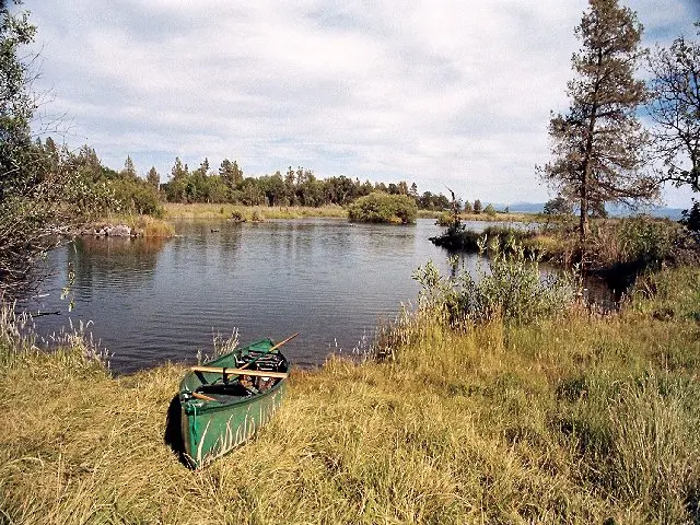
Ahjumawi Lava Springs requires more planning than almost any other California state park. It is accessible only by boat, with no roads and no services, in a corner of Shasta County most Californians have never thought to visit. Once you're in, you're paddling through one of the country's largest freshwater spring systems, over lava flows three to five thousand years old, past channels so clear the basalt bottom is visible in detail. The Achomawi people called this place "where the waters come together," and that remains the most accurate description of what makes it unlike anything else in the state park system.
Details
- 🏞️Type
- State Park
- 🏛️Managed by
- California State Parks
- 📍State
- CA
- 🗺️Address
- Jenner, CA, 95450
- 📞Phone
- (530) 335-2777
- 🕐Hours
- Sunrise to Sunset. Self-registration fees are due and payable upon entry.
- 🐾Pets Allowed
- No
- 📡GPS
- 41.10656, -121.41868
The Place
Five thousand years ago, lava poured across what is now northeastern Shasta County, covering more than two-thirds of this 5,930-acre park in jagged black basalt. Today those flows border a network of spring-fed waterways, Big Lake, Tule River, Ja-She Creek, Lava Creek, and Fall River, which together discharge roughly 1.2 billion gallons of fresh water daily, filtered through the Medicine Lake Volcano highlands. The result is an otherworldly landscape: brilliant aqua channels threading through black rock, small tree-studded islets, and wildlife density that catches first-time visitors off guard.
Bald eagles, ospreys, great blue herons, American white pelicans, and snow geese are regular. Ancient rock-wall fish traps built by the Achomawi people remain visible along the shoreline. The Spatter Cone Loop Trail (roughly 5 miles) crosses volcanic terrain with views north to Mt. Shasta at 14,179 feet and south to Lassen Peak at 10,457 feet.
Getting There
This is the detail that filters the casual visitor: there are no public roads into the park, no vehicle access of any kind. The launch point is the PG&E "Rat Farm" public boat ramp on Big Lake, reached from McArthur by heading north off Highway 299 on Main Street, past the Intermountain Fairgrounds, crossing a canal, then 3 miles north on a graded dirt road to the ramp. Kayaks and canoes are strongly preferred; the channels are shallow in places and larger powerboats don't navigate them well. Bring everything you need. There are no services inside the park.
When to Go
Spring and fall are the practical windows. Summer brings significant heat and, more consequentially, aggressive mosquitoes; the spring-fed wetlands generate serious insect pressure from late spring through August. Winter is cold and wet. In the shoulder seasons, particularly spring when water levels are high and bugs haven't fully arrived, visitation is extremely low and the park is essentially yours.
What to Do
Paddling is the core experience and one of California's better-kept secrets. The interconnected waterways offer miles of exploration through clear spring-fed channels, past lava outcroppings and islets. Hiking is possible on 20-plus miles of trails, though the backcountry is genuinely rugged; jagged basalt is unforgiving terrain and trail maintenance is limited. Wildlife observation is productive year-round, with peak birding in spring and fall migrations.
Reservations & Fees
Nine primitive campsites are available first-come, first-served: three near Ja-She Creek, three at Crystal Springs, and three on the north shore of Horr Pond, each with a pit toilet nearby. Self-registration fees are due upon entry. No reservations through ReserveCalifornia. Water is available from springs but must be purified. Pack out all trash. Dogs are not allowed. Bear canisters are required for food storage at campsites.